Villefranche-de-Lauragais elevation
Villefranche-de-Lauragais (Occitanie, Haute-Garonne), France elevation is 182 meters and Villefranche-de-Lauragais elevation in feet is 597 ft above sea level [src 1]. Villefranche-de-Lauragais is a populated place (feature code) with elevation that is 8 meters (26 ft) bigger than average city elevation in France.
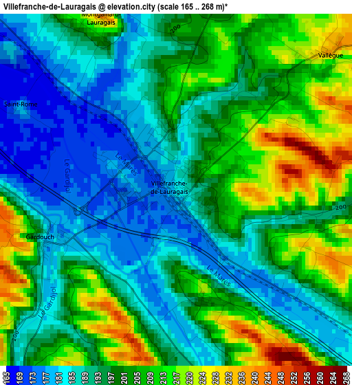
Below is the Elevation map of Villefranche-de-Lauragais, which displays elevation range with different colors. Scale of the first map is from 165 to 268 m (541 to 879 ft) with average elevation of 197.6 meters (=648 ft) [note 1]
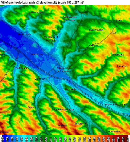
These maps also provides idea of topography and contour of this city, they are displayed at different zoom levels. More info about maps, scale and edge coordinates you can find below images.
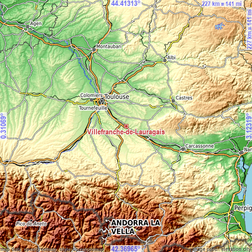
| \ | Map #1 | Map #2 | Topo.Map |
| Scale [m] | 165..268 m | 158..297 m | × |
| Scale [ft] | 541..879 ft | 518..974 ft | × |
| Average | 197.6 m = 648 ft | 213.4 m = 700 ft | × |
| Width | 7.1 km = 4.4 mi | 14.2 km = 8.8 mi | 227.2 km = 141.2 mi |
| Height | 7.1 km = 4.4 mi | 14.2 km = 8.8 mi | 227.2 km = 141.2 mi |
| ↑Max Latitude | 43.431921° | 43.463825° | 44.41313° |
| Latitude at center | 43.4° | 43.4° | 43.4° |
| ↓Min Latitude | 43.368062° | 43.336107° | 42.36965° |
| ← Min Longitude | 1.672995° | 1.629049° | 0.31069° |
| Longitude center | 1.71694° | 1.71694° | 1.71694° |
| →Max Longitude | 1.760885° | 1.804831° | 3.12319° |
Nearby cities:
Cities around Villefranche-de-Lauragais sort by population:
• Baziège elevation 162 m
10.3 km,  306°
306°
• Montgiscard 184 m
13.8 km,  299°
299°
• Caraman 250 m
15.2 km,  13°
13°
• Ayguesvives 191 m
10.6 km,  292°
292°
• Calmont 215 m
14.4 km,  209°
209°
• Saint-Félix-Lauragais 334 m
14.8 km,  68°
68°
• Nailloux 280 m
9 km,  237°
237°
• Avignonet-Lauragais 209 m
7.7 km,  118°
118°
• Gardouch 188 m
2.9 km,  249°
249°
• Villenouvelle 175 m
5.9 km, 312°
• Labastide-Beauvoir 263 m
10 km,  335°
335°
• Montlaur 161 m
15.6 km, 309°
Multilingual:
 En español:
Villefranche-de-Lauragais elevación 182 m.
 En France:
Villefranche-de-Lauragais élévation 182 m.
 Auf Deutsch:
Villefranche-de-Lauragais höhe über dem Meeresspiegel ist 182 m.
 На русском:
Вильфранш-де-Лораге высота над уровнем моря 182 м
Sources and notes:
- [note 1] Map square and city borders are not equal. Map elevation data is calculated only from area inside that square.
- [src 1] Elevation data from geonames database provided with same terms of usage.
- [src 2] The elevation map of Villefranche-de-Lauragais is generated using elevation data from NASA's 3 arcsec (90m) resolution SRTM data.
- [src 3] Base (background) map © OpenStreetMap contributors tiles are generated by Geofabrik and OpenTopoMap.
Copyright & License:
This Villefranche-de-Lauragais Elevation Map is licensed under CC BY-SA. You may reuse any part from this page, if you give a proper credit by linking to this URL:
 More info on terms of use page.