Caudry elevation
Caudry (Hauts-de-France, Nord), France elevation is 115 meters and Caudry elevation in feet is 377 ft above sea level [src 1]. Caudry is a populated place (feature code) with elevation that is 59 meters (194 ft) smaller than average city elevation in France.
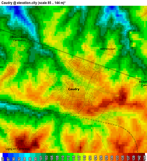
Below is the Elevation map of Caudry, which displays elevation range with different colors. Scale of the first map is from 85 to 144 m (279 to 472 ft) with average elevation of 115.8 meters (=380 ft) [note 1]
These maps also provides idea of topography and contour of this city, they are displayed at different zoom levels. More info about maps, scale and edge coordinates you can find below images.
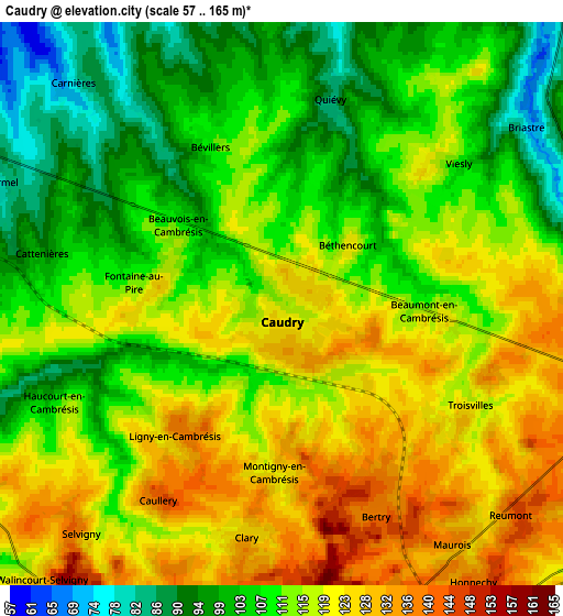
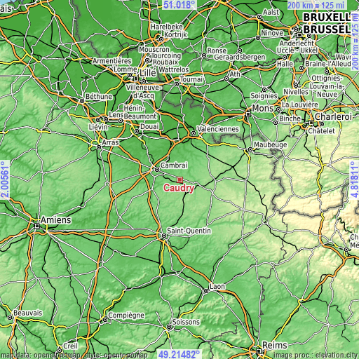
| \ | Map #1 | Map #2 | Topo.Map |
| Scale [m] | 85..144 m | 57..165 m | × |
| Scale [ft] | 279..472 ft | 187..541 ft | × |
| Average | 115.8 m = 380 ft | 113.3 m = 372 ft | × |
| Width | 6.27 km = 3.9 mi | 12.53 km = 7.8 mi | 200.5 km = 124.6 mi |
| Height | 6.27 km = 3.9 mi | 12.53 km = 7.8 mi | 200.5 km = 124.6 mi |
| ↑Max Latitude | 50.153066° | 50.181215° | 51.018° |
| Latitude at center | 50.1249° | 50.1249° | 50.1249° |
| ↓Min Latitude | 50.096718° | 50.068519° | 49.21482° |
| ← Min Longitude | 3.367915° | 3.323969° | 2.00561° |
| Longitude center | 3.41186° | 3.41186° | 3.41186° |
| →Max Longitude | 3.455805° | 3.499751° | 4.81811° |
Nearby cities:
Cities around Caudry sort by population:
• Avesnes-les-Aubert elevation 58 m
8.6 km,  346°
346°
• Bertry 142 m
4.7 km,  152°
152°
• Selvigny 139 m
6.7 km,  221°
221°
• Walincourt-Selvigny 129 m
8.6 km, 220°
• Beauvois-en-Cambrésis 114 m
2.7 km,  300°
300°
• Quiévy 83 m
4.9 km,  13°
13°
• Ligny-en-Cambrésis 139 m
3.6 km, 222°
• Saint-Hilaire-lez-Cambrai 95 m
6.6 km,  0°
0°
• Viesly 116 m
4.8 km,  48°
48°
• Fontaine-au-Pire 117 m
2.6 km,  288°
288°
• Clary 128 m
5.3 km,  189°
189°
• Saint-Python 65 m
8.7 km,  33°
33°
Multilingual:
 En español:
Caudry elevación 115 m.
 En France:
Caudry élévation 115 m.


Sources and notes:
- [note 1] Map square and city borders are not equal. Map elevation data is calculated only from area inside that square.
- [src 1] Elevation data from geonames database provided with same terms of usage.
- [src 2] The elevation map of Caudry is generated using elevation data from NASA's 3 arcsec (90m) resolution SRTM data.
- [src 3] Base (background) map © OpenStreetMap contributors tiles are generated by Geofabrik and OpenTopoMap.
Copyright & License:
This Caudry Elevation Map is licensed under CC BY-SA. You may reuse any part from this page, if you give a proper credit by linking to this URL:
 More info on terms of use page.