Saint-Python elevation
Saint-Python (Hauts-de-France, Nord), France elevation is 65 meters and Saint-Python elevation in feet is 213 ft above sea level [src 1]. Saint-Python is a populated place (feature code) with elevation that is 109 meters (358 ft) smaller than average city elevation in France.
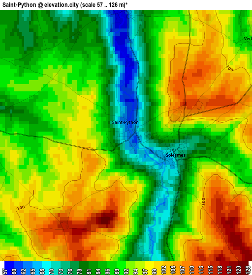
Below is the Elevation map of Saint-Python, which displays elevation range with different colors. Scale of the first map is from 57 to 126 m (187 to 413 ft) with average elevation of 92 meters (=302 ft) [note 1]
These maps also provides idea of topography and contour of this city, they are displayed at different zoom levels. More info about maps, scale and edge coordinates you can find below images.
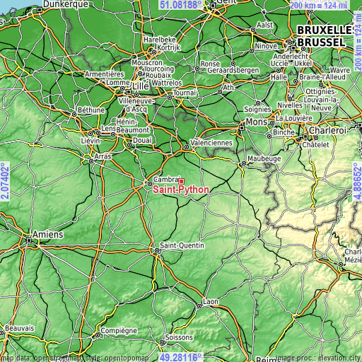
| \ | Map #1 | Topo.Map |
| Scale [m] | 57..126 m | × |
| Scale [ft] | 187..413 ft | × |
| Average | 92 m = 302 ft | × |
| Width | 6.26 km = 3.9 mi | 200.2 km = 124.4 mi |
| Height | 6.26 km = 3.9 mi | 200.2 km = 124.4 mi |
| ↑Max Latitude | 50.218137° | 51.08188° |
| Latitude at center | 50.19001° | 50.19001° |
| ↓Min Latitude | 50.161866° | 49.28116° |
| ← Min Longitude | 3.436325° | 2.07402° |
| Longitude center | 3.48027° | 3.48027° |
| →Max Longitude | 3.524215° | 4.88652° |
Nearby cities:
Cities around Saint-Python sort by population:
• Caudry elevation 115 m
8.7 km,  213°
213°
• Solesmes 76 m
1.4 km,  115°
115°
• Avesnes-les-Aubert 58 m
7 km,  279°
279°
• Haspres 44 m
8.8 km,  329°
329°
• Quiévy 83 m
4.4 km,  236°
236°
• Saulzoir 57 m
6.2 km,  335°
335°
• Haussy 57 m
3.2 km,  355°
355°
• Saint-Hilaire-lez-Cambrai 95 m
4.8 km,  262°
262°
• Saint-Aubert 68 m
4.9 km,  294°
294°
• Viesly 116 m
4.3 km,  197°
197°
• Villers-en-Cauchies 75 m
6.7 km,  306°
306°
• Vendegies-sur-Écaillon 61 m
8.4 km,  15°
15°
Multilingual:
 En español:
Saint-Python elevación 65 m.
 En France:
Saint-Python élévation 65 m.
 Auf Deutsch:
Saint-Python höhe über dem Meeresspiegel ist 65 m.

Sources and notes:
- [note 1] Map square and city borders are not equal. Map elevation data is calculated only from area inside that square.
- [src 1] Elevation data from geonames database provided with same terms of usage.
- [src 2] The elevation map of Saint-Python is generated using elevation data from NASA's 3 arcsec (90m) resolution SRTM data.
- [src 3] Base (background) map © OpenStreetMap contributors tiles are generated by Geofabrik and OpenTopoMap.
Copyright & License:
This Saint-Python Elevation Map is licensed under CC BY-SA. You may reuse any part from this page, if you give a proper credit by linking to this URL:
 More info on terms of use page.