Champagne-au-Mont-d’Or elevation
Champagne-au-Mont-d’Or (Auvergne-Rhône-Alpes, Département du Rhône), France elevation is 270 meters and Champagne-au-Mont-d’Or elevation in feet is 886 ft above sea level [src 1]. Champagne-au-Mont-d’Or is a populated place (feature code) with elevation that is 96 meters (315 ft) bigger than average city elevation in France.
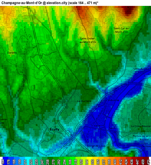
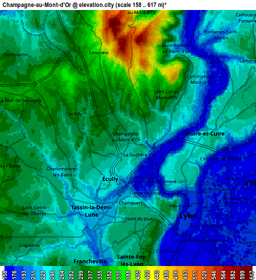
Below is the Elevation map of Champagne-au-Mont-d’Or, which displays elevation range with different colors. Scale of the first map is from 164 to 471 m (538 to 1545 ft) with average elevation of 267.6 meters (=878 ft) [note 1]
These maps also provides idea of topography and contour of this city, they are displayed at different zoom levels. More info about maps, scale and edge coordinates you can find below images.
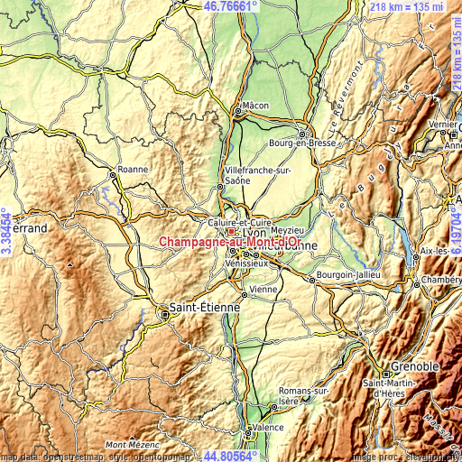
| \ | Map #1 | Map #2 | Topo.Map |
| Scale [m] | 164..471 m | 158..617 m | × |
| Scale [ft] | 538..1545 ft | 518..2024 ft | × |
| Average | 267.6 m = 878 ft | 268.7 m = 882 ft | × |
| Width | 6.81 km = 4.2 mi | 13.63 km = 8.5 mi | 218 km = 135.5 mi |
| Height | 6.81 km = 4.2 mi | 13.63 km = 8.5 mi | 218 km = 135.5 mi |
| ↑Max Latitude | 45.825382° | 45.855996° | 46.76661° |
| Latitude at center | 45.79475° | 45.79475° | 45.79475° |
| ↓Min Latitude | 45.764102° | 45.733436° | 44.80564° |
| ← Min Longitude | 4.746845° | 4.702899° | 3.38454° |
| Longitude center | 4.79079° | 4.79079° | 4.79079° |
| →Max Longitude | 4.834735° | 4.878681° | 6.19704° |
Nearby cities:
Cities around Champagne-au-Mont-d’Or sort by population:
• Lyon elevation 173 m
6.7 km,  139°
139°
• Caluire-et-Cuire 237 m
4.3 km,  90°
90°
• Sainte-Foy-lès-Lyon 176 m
6.8 km,  172°
172°
• Écully 211 m
2.5 km,  204°
204°
• Tassin-la-Demi-Lune 262 m
4.4 km,  182°
182°
• Dardilly 327 m
3.2 km,  292°
292°
• Fontaines-sur-Saône 235 m
6.2 km,  42°
42°
• Saint-Genis-les-Ollières 255 m
6.5 km,  230°
230°
• Charbonnières-les-Bains 267 m
3.8 km,  245°
245°
• La Tour-de-Salvagny 318 m
6.1 km, 290°
• Limonest 409 m
4.9 km,  342°
342°
• Couzon-au-Mont-d’Or 187 m
6.3 km,  28°
28°
Multilingual:
 En español:
Champagne-au-Mont-d’Or elevación 270 m.
 En France:
Champagne-au-Mont-d’Or élévation 270 m.
 Auf Deutsch:
Champagne-au-Mont-d’Or höhe über dem Meeresspiegel ist 270 m.
 На русском:
Champagne-au-Mont-d’Or высота над уровнем моря 270 м
Sources and notes:
- [note 1] Map square and city borders are not equal. Map elevation data is calculated only from area inside that square.
- [src 1] Elevation data from geonames database provided with same terms of usage.
- [src 2] The elevation map of Champagne-au-Mont-d’Or is generated using elevation data from NASA's 3 arcsec (90m) resolution SRTM data.
- [src 3] Base (background) map © OpenStreetMap contributors tiles are generated by Geofabrik and OpenTopoMap.
Copyright & License:
This Champagne-au-Mont-d’Or Elevation Map is licensed under CC BY-SA. You may reuse any part from this page, if you give a proper credit by linking to this URL:
 More info on terms of use page.