Sainte-Foy-lès-Lyon elevation
Sainte-Foy-lès-Lyon (Auvergne-Rhône-Alpes, Département du Rhône), France elevation is 176 meters and Sainte-Foy-lès-Lyon elevation in feet is 577 ft above sea level [src 1]. Sainte-Foy-lès-Lyon is a populated place (feature code) with elevation that is 2 meters (7 ft) bigger than average city elevation in France.
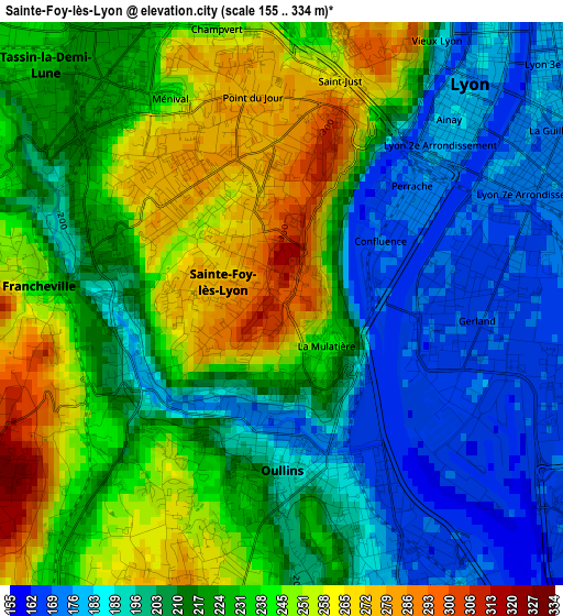
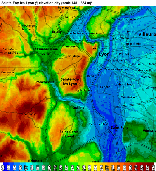
Below is the Elevation map of Sainte-Foy-lès-Lyon, which displays elevation range with different colors. Scale of the first map is from 155 to 334 m (509 to 1096 ft) with average elevation of 219.6 meters (=720 ft) [note 1]
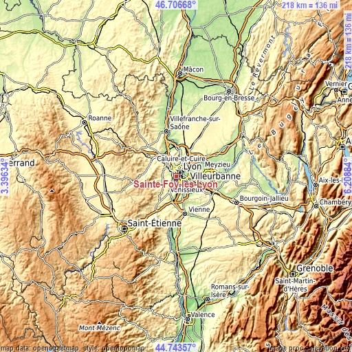
These maps also provides idea of topography and contour of this city, they are displayed at different zoom levels. More info about maps, scale and edge coordinates you can find below images.
| \ | Map #1 | Map #2 | Topo.Map |
| Scale [m] | 155..334 m | 148..334 m | × |
| Scale [ft] | 509..1096 ft | 486..1096 ft | × |
| Average | 219.6 m = 720 ft | 224.6 m = 737 ft | × |
| Width | 6.82 km = 4.2 mi | 13.64 km = 8.5 mi | 218.3 km = 135.6 mi |
| Height | 6.82 km = 4.2 mi | 13.64 km = 8.5 mi | 218.3 km = 135.6 mi |
| ↑Max Latitude | 45.764415° | 45.795063° | 46.70668° |
| Latitude at center | 45.73375° | 45.73375° | 45.73375° |
| ↓Min Latitude | 45.703068° | 45.672369° | 44.74357° |
| ← Min Longitude | 4.758645° | 4.714699° | 3.39634° |
| Longitude center | 4.80259° | 4.80259° | 4.80259° |
| →Max Longitude | 4.846535° | 4.890481° | 6.20884° |
Nearby cities:
Cities around Sainte-Foy-lès-Lyon sort by population:
• Lyon elevation 173 m
3.8 km,  64°
64°
• Oullins 187 m
2.2 km,  170°
170°
• Saint-Genis-Laval 245 m
4.3 km,  189°
189°
• Écully 211 m
4.9 km,  336°
336°
• Tassin-la-Demi-Lune 262 m
2.6 km,  334°
334°
• Saint-Fons 181 m
4.8 km,  125°
125°
• Francheville 208 m
3 km,  275°
275°
• Pierre-Bénite 170 m
3.8 km,  153°
153°
• Craponne 275 m
6.3 km, 281°
• Chaponost 317 m
5.4 km,  240°
240°
• La Mulatière 167 m
1 km, 129°
• Saint-Genis-les-Ollières 255 m
6.5 km,  293°
293°
Multilingual:
 En español:
Sainte-Foy-lès-Lyon elevación 176 m.
 En France:
Sainte-Foy-lès-Lyon élévation 176 m.
 Auf Deutsch:
Sainte-Foy-lès-Lyon höhe über dem Meeresspiegel ist 176 m.

Sources and notes:
- [note 1] Map square and city borders are not equal. Map elevation data is calculated only from area inside that square.
- [src 1] Elevation data from geonames database provided with same terms of usage.
- [src 2] The elevation map of Sainte-Foy-lès-Lyon is generated using elevation data from NASA's 3 arcsec (90m) resolution SRTM data.
- [src 3] Base (background) map © OpenStreetMap contributors tiles are generated by Geofabrik and OpenTopoMap.
Copyright & License:
This Sainte-Foy-lès-Lyon Elevation Map is licensed under CC BY-SA. You may reuse any part from this page, if you give a proper credit by linking to this URL:
 More info on terms of use page.