Chandon elevation
Chandon (Auvergne-Rhône-Alpes, Département de la Loire), France elevation is 343 meters and Chandon elevation in feet is 1125 ft above sea level [src 1]. Chandon is a populated place (feature code) with elevation that is 169 meters (554 ft) bigger than average city elevation in France.
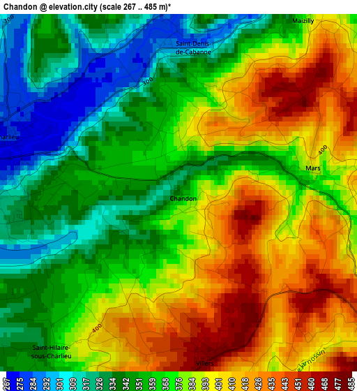
Below is the Elevation map of Chandon, which displays elevation range with different colors. Scale of the first map is from 267 to 485 m (876 to 1591 ft) with average elevation of 373.5 meters (=1225 ft) [note 1]
These maps also provides idea of topography and contour of this city, they are displayed at different zoom levels. More info about maps, scale and edge coordinates you can find below images.
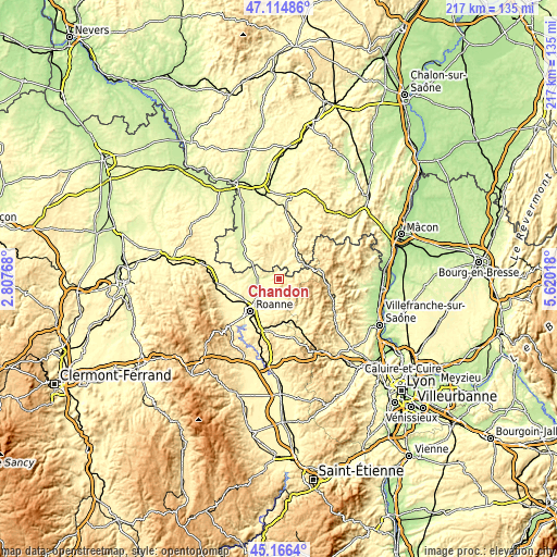
| \ | Map #1 | Topo.Map |
| Scale [m] | 267..485 m | × |
| Scale [ft] | 876..1591 ft | × |
| Average | 373.5 m = 1225 ft | × |
| Width | 6.77 km = 4.2 mi | 216.6 km = 134.6 mi |
| Height | 6.77 km = 4.2 mi | 216.6 km = 134.6 mi |
| ↑Max Latitude | 46.179686° | 47.11486° |
| Latitude at center | 46.14925° | 46.14925° |
| ↓Min Latitude | 46.118797° | 45.1664° |
| ← Min Longitude | 4.169985° | 2.80768° |
| Longitude center | 4.21393° | 4.21393° |
| →Max Longitude | 4.257875° | 5.62018° |
Nearby cities:
Cities around Chandon sort by population:
• Cours-la-Ville elevation 505 m
9.6 km,  124°
124°
• Chauffailles 405 m
11.6 km,  56°
56°
• Charlieu 273 m
3.5 km,  293°
293°
• Bourg-de-Thizy 402 m
14.4 km,  152°
152°
• Pouilly-sous-Charlieu 280 m
7.8 km,  266°
266°
• Perreux 316 m
13.9 km,  209°
209°
• Briennon 282 m
10.6 km, 271°
• Saint-Nizier-sous-Charlieu 305 m
6.9 km, 273°
• Vougy 298 m
8.9 km,  236°
236°
• Belmont-de-la-Loire 527 m
10.4 km,  79°
79°
• Saint-Denis-de-Cabanne 349 m
2.6 km,  0°
0°
• Coutouvre 427 m
8.5 km,  184°
184°
Multilingual:
 En español:
Chandon elevación 343 m.
 En France:
Chandon élévation 343 m.


Sources and notes:
- [note 1] Map square and city borders are not equal. Map elevation data is calculated only from area inside that square.
- [src 1] Elevation data from geonames database provided with same terms of usage.
- [src 2] The elevation map of Chandon is generated using elevation data from NASA's 3 arcsec (90m) resolution SRTM data.
- [src 3] Base (background) map © OpenStreetMap contributors tiles are generated by Geofabrik and OpenTopoMap.
Copyright & License:
This Chandon Elevation Map is licensed under CC BY-SA. You may reuse any part from this page, if you give a proper credit by linking to this URL:
 More info on terms of use page.