Chantilly elevation
Chantilly (Hauts-de-France, Département de l'Oise), France elevation is 53 meters and Chantilly elevation in feet is 174 ft above sea level [src 1]. Chantilly is a populated place (feature code) with elevation that is 121 meters (397 ft) smaller than average city elevation in France.
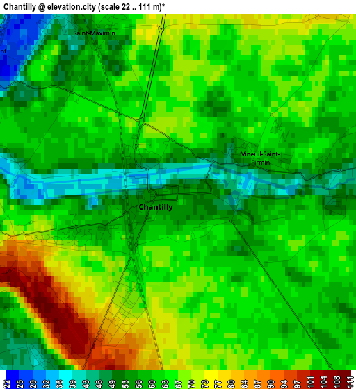
Below is the Elevation map of Chantilly, which displays elevation range with different colors. Scale of the first map is from 22 to 111 m (72 to 364 ft) with average elevation of 62.2 meters (=204 ft) [note 1]
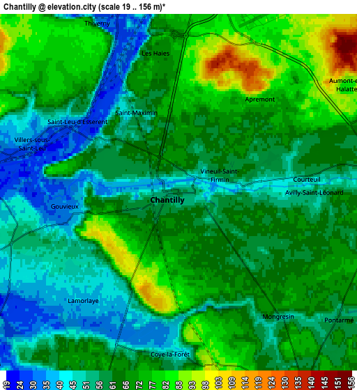
These maps also provides idea of topography and contour of this city, they are displayed at different zoom levels. More info about maps, scale and edge coordinates you can find below images.
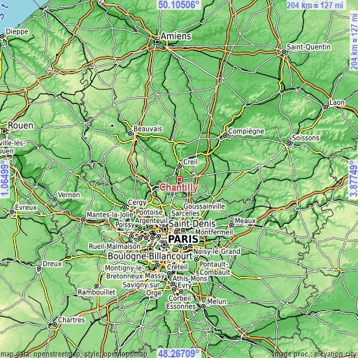
| \ | Map #1 | Map #2 | Topo.Map |
| Scale [m] | 22..111 m | 19..156 m | × |
| Scale [ft] | 72..364 ft | 62..512 ft | × |
| Average | 62.2 m = 204 ft | 63.4 m = 208 ft | × |
| Width | 6.39 km = 4 mi | 12.77 km = 7.9 mi | 204.4 km = 127 mi |
| Height | 6.39 km = 4 mi | 12.77 km = 7.9 mi | 204.3 km = 126.9 mi |
| ↑Max Latitude | 49.22332° | 49.252012° | 50.10506° |
| Latitude at center | 49.19461° | 49.19461° | 49.19461° |
| ↓Min Latitude | 49.165884° | 49.137141° | 48.26709° |
| ← Min Longitude | 2.427295° | 2.383349° | 1.06499° |
| Longitude center | 2.47124° | 2.47124° | 2.47124° |
| →Max Longitude | 2.515185° | 2.559131° | 3.87749° |
Nearby cities:
Cities around Chantilly sort by population:
• Creil elevation 73 m
7 km,  8°
8°
• Montataire 75 m
7.6 km,  341°
341°
• Gouvieux 32 m
4.2 km,  258°
258°
• Lamorlaye 60 m
4 km,  206°
206°
• Coye-la-Forêt 44 m
5.8 km,  180°
180°
• Orry-la-Ville 75 m
7.4 km,  156°
156°
• Précy-sur-Oise 36 m
7.3 km,  281°
281°
• Saint-Maximin 60 m
3.3 km, 337°
• Villers-sous-Saint-Leu 38 m
5.9 km,  289°
289°
• Vineuil-Saint-Firmin 58 m
1.9 km,  70°
70°
• Thiverny 30 m
6.9 km, 338°
• Avilly-Saint-Léonard 50 m
5.1 km,  90°
90°
Multilingual:
 En español:
Chantilly elevación 53 m.
 En France:
Chantilly élévation 53 m.
 Auf Deutsch:
Chantilly höhe über dem Meeresspiegel ist 53 m.

Sources and notes:
- [note 1] Map square and city borders are not equal. Map elevation data is calculated only from area inside that square.
- [src 1] Elevation data from geonames database provided with same terms of usage.
- [src 2] The elevation map of Chantilly is generated using elevation data from NASA's 3 arcsec (90m) resolution SRTM data.
- [src 3] Base (background) map © OpenStreetMap contributors tiles are generated by Geofabrik and OpenTopoMap.
Copyright & License:
This Chantilly Elevation Map is licensed under CC BY-SA. You may reuse any part from this page, if you give a proper credit by linking to this URL:
 More info on terms of use page.