Charny elevation
Charny (Île-de-France, Seine-et-Marne), France elevation is 105 meters and Charny elevation in feet is 344 ft above sea level [src 1]. Charny is a populated place (feature code) with elevation that is 69 meters (226 ft) smaller than average city elevation in France.
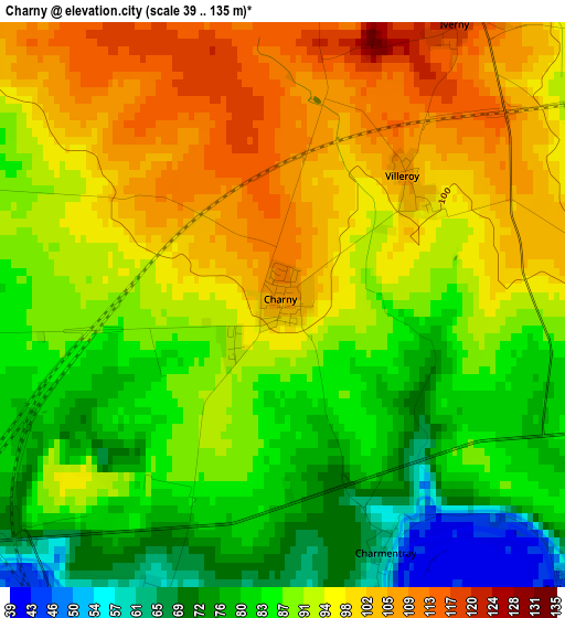
Below is the Elevation map of Charny, which displays elevation range with different colors. Scale of the first map is from 39 to 135 m (128 to 443 ft) with average elevation of 91.1 meters (=299 ft) [note 1]
These maps also provides idea of topography and contour of this city, they are displayed at different zoom levels. More info about maps, scale and edge coordinates you can find below images.
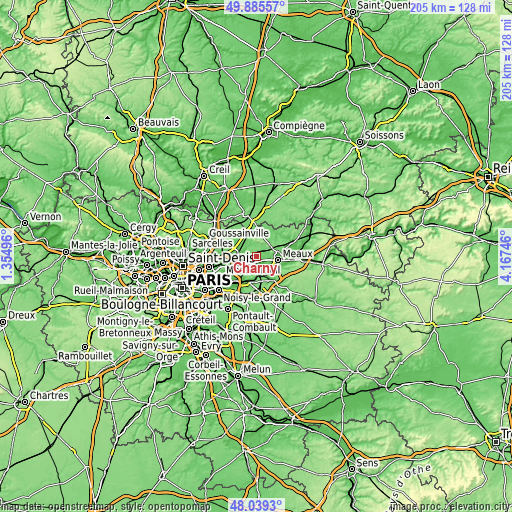
| \ | Map #1 | Topo.Map |
| Scale [m] | 39..135 m | × |
| Scale [ft] | 128..443 ft | × |
| Average | 91.1 m = 299 ft | × |
| Width | 6.42 km = 4 mi | 205.3 km = 127.6 mi |
| Height | 6.42 km = 4 mi | 205.3 km = 127.6 mi |
| ↑Max Latitude | 48.999819° | 49.88557° |
| Latitude at center | 48.97098° | 48.97098° |
| ↓Min Latitude | 48.942124° | 48.0393° |
| ← Min Longitude | 2.717265° | 1.35496° |
| Longitude center | 2.76121° | 2.76121° |
| →Max Longitude | 2.805155° | 4.16746° |
Nearby cities:
Cities around Charny sort by population:
• Meaux elevation 61 m
8.7 km,  97°
97°
• Claye-Souilly 52 m
6.2 km,  242°
242°
• Esbly 56 m
8.2 km,  152°
152°
• Crégy-lès-Meaux 87 m
8.3 km,  85°
85°
• Villenoy 52 m
8 km,  114°
114°
• Saint-Mard 110 m
8.7 km,  327°
327°
• Saint-Soupplets 105 m
8.2 km,  24°
24°
• Annet-sur-Marne 52 m
5.8 km,  211°
211°
• Juilly 87 m
6.2 km,  319°
319°
• Chauconin-Neufmontiers 88 m
6.5 km, 94°
• Mareuil-lès-Meaux 55 m
8.8 km,  124°
124°
• Monthyon 161 m
6.2 km,  49°
49°
Multilingual:
 En español:
Charny elevación 105 m.
 En France:
Charny élévation 105 m.


Sources and notes:
- [note 1] Map square and city borders are not equal. Map elevation data is calculated only from area inside that square.
- [src 1] Elevation data from geonames database provided with same terms of usage.
- [src 2] The elevation map of Charny is generated using elevation data from NASA's 3 arcsec (90m) resolution SRTM data.
- [src 3] Base (background) map © OpenStreetMap contributors tiles are generated by Geofabrik and OpenTopoMap.
Copyright & License:
This Charny Elevation Map is licensed under CC BY-SA. You may reuse any part from this page, if you give a proper credit by linking to this URL:
 More info on terms of use page.