Meaux elevation
Meaux (Île-de-France, Seine-et-Marne), France elevation is 61 meters and Meaux elevation in feet is 200 ft above sea level [src 1]. Meaux is a seat of a third-order administrative division (feature code) with elevation that is 113 meters (371 ft) smaller than average city elevation in France.
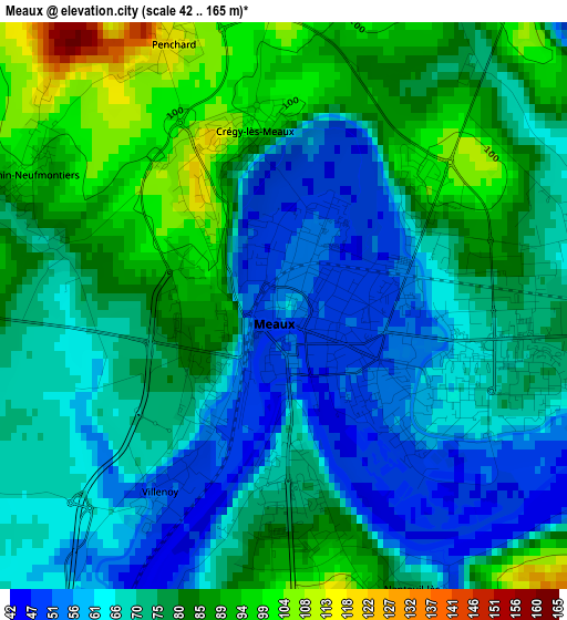
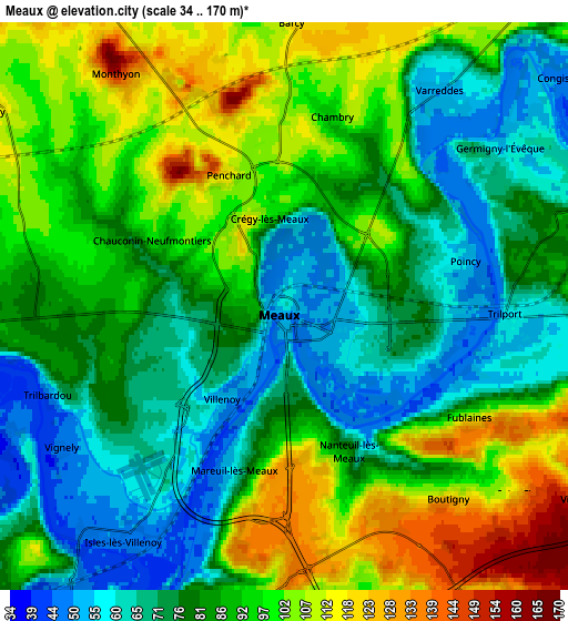
Below is the Elevation map of Meaux, which displays elevation range with different colors. Scale of the first map is from 42 to 165 m (138 to 541 ft) with average elevation of 74.4 meters (=244 ft) [note 1]
These maps also provides idea of topography and contour of this city, they are displayed at different zoom levels. More info about maps, scale and edge coordinates you can find below images.
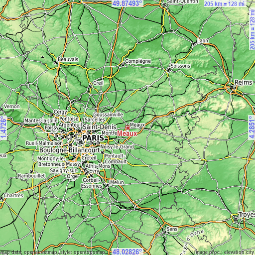
| \ | Map #1 | Map #2 | Topo.Map |
| Scale [m] | 42..165 m | 34..170 m | × |
| Scale [ft] | 138..541 ft | 112..558 ft | × |
| Average | 74.4 m = 244 ft | 86.3 m = 283 ft | × |
| Width | 6.42 km = 4 mi | 12.83 km = 8 mi | 205.3 km = 127.6 mi |
| Height | 6.42 km = 4 mi | 12.83 km = 8 mi | 205.3 km = 127.6 mi |
| ↑Max Latitude | 48.988985° | 49.017814° | 49.87493° |
| Latitude at center | 48.96014° | 48.96014° | 48.96014° |
| ↓Min Latitude | 48.931278° | 48.902399° | 48.02826° |
| ← Min Longitude | 2.834905° | 2.790959° | 1.4726° |
| Longitude center | 2.87885° | 2.87885° | 2.87885° |
| →Max Longitude | 2.922795° | 2.966741° | 4.2851° |
Nearby cities:
Cities around Meaux sort by population:
• Esbly elevation 56 m
7.8 km,  218°
218°
• Nanteuil-lès-Meaux 93 m
3.6 km,  159°
159°
• Trilport 57 m
5.3 km,  93°
93°
• Quincy-Voisins 130 m
6.6 km,  182°
182°
• Crégy-lès-Meaux 87 m
1.8 km,  350°
350°
• Villenoy 52 m
2.5 km,  212°
212°
• Varreddes 51 m
6 km,  36°
36°
• Chauconin-Neufmontiers 88 m
2.2 km,  289°
289°
• Mareuil-lès-Meaux 55 m
4 km,  198°
198°
• Condé-Sainte-Libiaire 76 m
7.6 km, 202°
• Monthyon 161 m
6.5 km,  323°
323°
• Fublaines 99 m
4.9 km,  120°
120°
Multilingual:
 En español:
Meaux elevación 61 m.
 En France:
Meaux élévation 61 m.


Sources and notes:
- [note 1] Map square and city borders are not equal. Map elevation data is calculated only from area inside that square.
- [src 1] Elevation data from geonames database provided with same terms of usage.
- [src 2] The elevation map of Meaux is generated using elevation data from NASA's 3 arcsec (90m) resolution SRTM data.
- [src 3] Base (background) map © OpenStreetMap contributors tiles are generated by Geofabrik and OpenTopoMap.
Copyright & License:
This Meaux Elevation Map is licensed under CC BY-SA. You may reuse any part from this page, if you give a proper credit by linking to this URL:
 More info on terms of use page.