Châteaugiron elevation
Châteaugiron (Brittany, Département d'Ille-et-Vilaine), France elevation is 54 meters and Châteaugiron elevation in feet is 177 ft above sea level [src 1]. Châteaugiron is a populated place (feature code) with elevation that is 120 meters (394 ft) smaller than average city elevation in France.
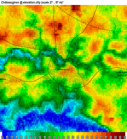
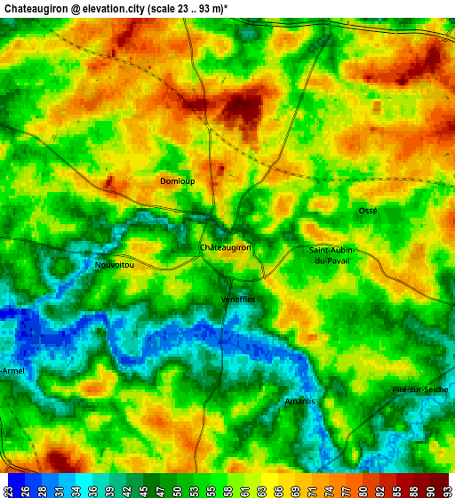
Below is the Elevation map of Châteaugiron, which displays elevation range with different colors. Scale of the first map is from 27 to 87 m (89 to 285 ft) with average elevation of 55.5 meters (=182 ft) [note 1]
These maps also provides idea of topography and contour of this city, they are displayed at different zoom levels. More info about maps, scale and edge coordinates you can find below images.
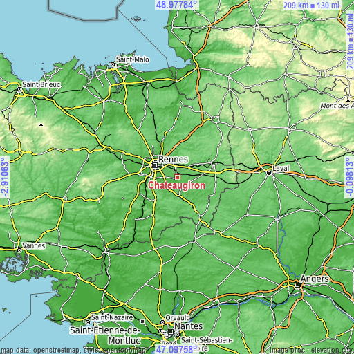
| \ | Map #1 | Map #2 | Topo.Map |
| Scale [m] | 27..87 m | 23..93 m | × |
| Scale [ft] | 89..285 ft | 75..305 ft | × |
| Average | 55.5 m = 182 ft | 57.2 m = 188 ft | × |
| Width | 6.53 km = 4.1 mi | 13.07 km = 8.1 mi | 209.1 km = 129.9 mi |
| Height | 6.53 km = 4.1 mi | 13.07 km = 8.1 mi | 209.1 km = 129.9 mi |
| ↑Max Latitude | 48.07566° | 48.105014° | 48.97784° |
| Latitude at center | 48.04629° | 48.04629° | 48.04629° |
| ↓Min Latitude | 48.016903° | 47.987499° | 47.09758° |
| ← Min Longitude | -1.548325° | -1.592271° | -2.91063° |
| Longitude center | -1.50438° | -1.50438° | -1.50438° |
| →Max Longitude | -1.460435° | -1.416489° | -0.09813° |
Nearby cities:
Cities around Châteaugiron sort by population:
• Vern-sur-Seiche elevation 50 m
7.2 km,  268°
268°
• Chantepie 52 m
9.5 km,  299°
299°
• Noyal-sur-Vilaine 77 m
7.5 km,  349°
349°
• Servon-sur-Vilaine 48 m
9 km,  21°
21°
• Nouvoitou 56 m
3.2 km,  259°
259°
• Corps-Nuds 68 m
9.5 km,  218°
218°
• Piré-sur-Seiche 54 m
6.9 km,  126°
126°
• Domagné 81 m
8.7 km,  71°
71°
• Saint-Armel 37 m
7.5 km,  240°
240°
• Brécé 46 m
7.1 km,  14°
14°
• Amanlis 35 m
4.8 km,  154°
154°
• Ossé 60 m
4.1 km,  75°
75°
Multilingual:
 En español:
Châteaugiron elevación 54 m.
 En France:
Châteaugiron élévation 54 m.
 Auf Deutsch:
Châteaugiron höhe über dem Meeresspiegel ist 54 m.

Sources and notes:
- [note 1] Map square and city borders are not equal. Map elevation data is calculated only from area inside that square.
- [src 1] Elevation data from geonames database provided with same terms of usage.
- [src 2] The elevation map of Châteaugiron is generated using elevation data from NASA's 3 arcsec (90m) resolution SRTM data.
- [src 3] Base (background) map © OpenStreetMap contributors tiles are generated by Geofabrik and OpenTopoMap.
Copyright & License:
This Châteaugiron Elevation Map is licensed under CC BY-SA. You may reuse any part from this page, if you give a proper credit by linking to this URL:
 More info on terms of use page.