Châtel elevation
Châtel (Auvergne-Rhône-Alpes, Haute-Savoie), France elevation is 1371 meters and Châtel elevation in feet is 4498 ft above sea level [src 1]. Châtel is a populated place (feature code) with elevation that is 1197 meters (3927 ft) bigger than average city elevation in France.
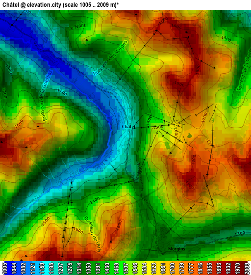
Below is the Elevation map of Châtel, which displays elevation range with different colors. Scale of the first map is from 1005 to 2009 m (3297 to 6591 ft) with average elevation of 1496.8 meters (=4911 ft) [note 1]
These maps also provides idea of topography and contour of this city, they are displayed at different zoom levels. More info about maps, scale and edge coordinates you can find below images.
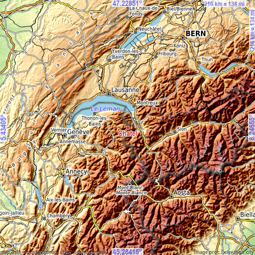
| \ | Map #1 | Topo.Map |
| Scale [m] | 1005..2009 m | × |
| Scale [ft] | 3297..6591 ft | × |
| Average | 1496.8 m = 4911 ft | × |
| Width | 6.76 km = 4.2 mi | 216.2 km = 134.3 mi |
| Height | 6.76 km = 4.2 mi | 216.2 km = 134.3 mi |
| ↑Max Latitude | 46.295322° | 47.22851° |
| Latitude at center | 46.26495° | 46.26495° |
| ↓Min Latitude | 46.234561° | 45.28415° |
| ← Min Longitude | 6.796355° | 5.43405° |
| Longitude center | 6.8403° | 6.8403° |
| →Max Longitude | 6.884245° | 8.24655° |
Nearby cities:
Cities around Châtel sort by population:
• Morzine elevation 953 m
13.9 km,  227°
227°
• Samoëns 706 m
22.1 km,  203°
203°
• Neuvecelle 490 m
22.7 km,  309°
309°
• Lugrin 381 m
21 km,  316°
316°
• Saint-Paul-en-Chablais 820 m
20.9 km, 307°
• Abondance 1080 m
9.3 km,  279°
279°
• Les Gets 1166 m
18.2 km, 227°
• Bellevaux 1017 m
23.6 km,  268°
268°
• Féternes 724 m
24.6 km,  294°
294°
• Saint-Jean-d’Aulps 1023 m
14.8 km,  256°
256°
• Maxilly-sur-Léman 484 m
21.9 km, 312°
• Larringes 801 m
23.7 km,  299°
299°
Multilingual:
 En español:
Châtel elevación 1371 m.
 En France:
Châtel élévation 1371 m.


Sources and notes:
- [note 1] Map square and city borders are not equal. Map elevation data is calculated only from area inside that square.
- [src 1] Elevation data from geonames database provided with same terms of usage.
- [src 2] The elevation map of Châtel is generated using elevation data from NASA's 3 arcsec (90m) resolution SRTM data.
- [src 3] Base (background) map © OpenStreetMap contributors tiles are generated by Geofabrik and OpenTopoMap.
Copyright & License:
This Châtel Elevation Map is licensed under CC BY-SA. You may reuse any part from this page, if you give a proper credit by linking to this URL:
 More info on terms of use page.