Neuvecelle elevation
Neuvecelle (Auvergne-Rhône-Alpes, Haute-Savoie), France elevation is 490 meters and Neuvecelle elevation in feet is 1608 ft above sea level [src 1]. Neuvecelle is a populated place (feature code) with elevation that is 316 meters (1037 ft) bigger than average city elevation in France.
Below is the Elevation map of Neuvecelle, which displays elevation range with different colors. Scale of the first map is from 369 to 976 m (1211 to 3202 ft) with average elevation of 574.2 meters (=1884 ft) [note 1]
These maps also provides idea of topography and contour of this city, they are displayed at different zoom levels. More info about maps, scale and edge coordinates you can find below images.
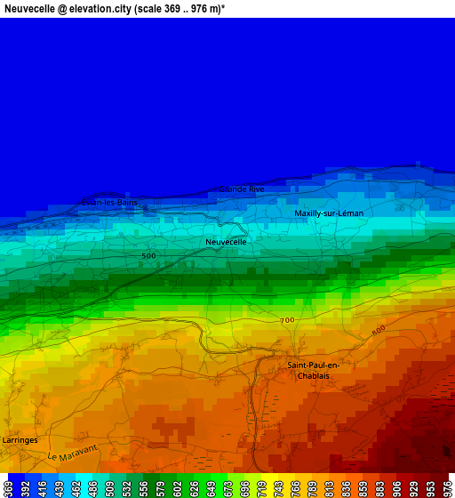
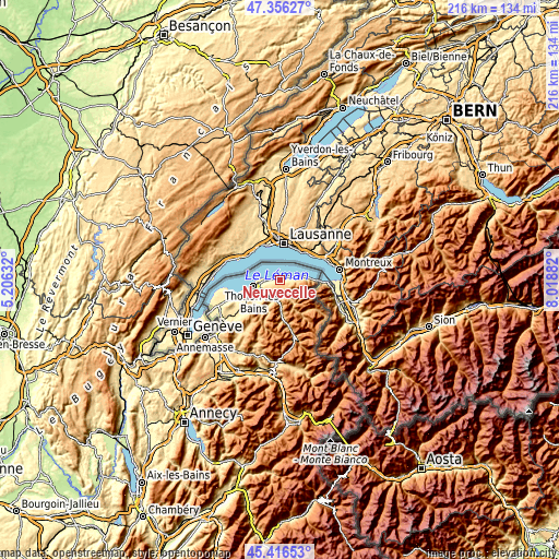
| \ | Map #1 | Topo.Map |
| Scale [m] | 369..976 m | × |
| Scale [ft] | 1211..3202 ft | × |
| Average | 574.2 m = 1884 ft | × |
| Width | 6.74 km = 4.2 mi | 215.7 km = 134 mi |
| Height | 6.74 km = 4.2 mi | 215.7 km = 134 mi |
| ↑Max Latitude | 46.42532° | 47.35627° |
| Latitude at center | 46.39502° | 46.39502° |
| ↓Min Latitude | 46.364703° | 45.41653° |
| ← Min Longitude | 6.568625° | 5.20632° |
| Longitude center | 6.61257° | 6.61257° |
| →Max Longitude | 6.656515° | 8.01882° |
Nearby cities:
Cities around Neuvecelle sort by population:
• Thonon-les-Bains elevation 437 m
10.5 km,  255°
255°
• Évian-les-Bains 388 m
2 km,  289°
289°
• Publier 502 m
5.4 km, 261°
• Allinges 532 m
13.2 km,  239°
239°
• Lugrin 381 m
3.2 km,  75°
75°
• Saint-Paul-en-Chablais 820 m
2 km,  151°
151°
• Marin 580 m
6.9 km, 255°
• Féternes 724 m
6.6 km,  228°
228°
• Lyaud 789 m
9.1 km, 227°
• Maxilly-sur-Léman 484 m
1.5 km, 75°
• Larringes 801 m
4.3 km, 227°
• Armoy 485 m
8.8 km, 236°
Multilingual:
 En español:
Neuvecelle elevación 490 m.
 En France:
Neuvecelle élévation 490 m.
 Auf Deutsch:
Neuvecelle höhe über dem Meeresspiegel ist 490 m.

Sources and notes:
- [note 1] Map square and city borders are not equal. Map elevation data is calculated only from area inside that square.
- [src 1] Elevation data from geonames database provided with same terms of usage.
- [src 2] The elevation map of Neuvecelle is generated using elevation data from NASA's 3 arcsec (90m) resolution SRTM data.
- [src 3] Base (background) map © OpenStreetMap contributors tiles are generated by Geofabrik and OpenTopoMap.
Copyright & License:
This Neuvecelle Elevation Map is licensed under CC BY-SA. You may reuse any part from this page, if you give a proper credit by linking to this URL:
 More info on terms of use page.