Châtillon-en-Vendelais elevation
Châtillon-en-Vendelais (Brittany, Département d'Ille-et-Vilaine), France elevation is 134 meters and Châtillon-en-Vendelais elevation in feet is 440 ft above sea level [src 1]. Châtillon-en-Vendelais is a populated place (feature code) with elevation that is 40 meters (131 ft) smaller than average city elevation in France.
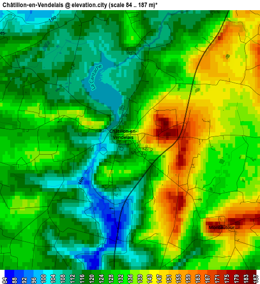
Below is the Elevation map of Châtillon-en-Vendelais, which displays elevation range with different colors. Scale of the first map is from 84 to 187 m (276 to 614 ft) with average elevation of 127.8 meters (=419 ft) [note 1]
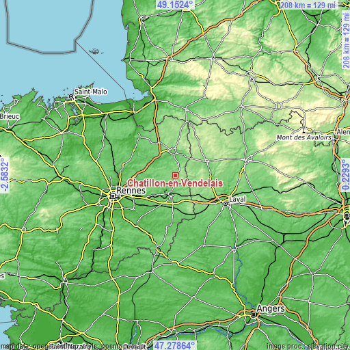
These maps also provides idea of topography and contour of this city, they are displayed at different zoom levels. More info about maps, scale and edge coordinates you can find below images.
| \ | Map #1 | Topo.Map |
| Scale [m] | 84..187 m | × |
| Scale [ft] | 276..614 ft | × |
| Average | 127.8 m = 419 ft | × |
| Width | 6.51 km = 4 mi | 208.3 km = 129.4 mi |
| Height | 6.51 km = 4 mi | 208.3 km = 129.4 mi |
| ↑Max Latitude | 48.253359° | 49.1524° |
| Latitude at center | 48.22409° | 48.22409° |
| ↓Min Latitude | 48.194804° | 47.27864° |
| ← Min Longitude | -1.220895° | -2.5832° |
| Longitude center | -1.17695° | -1.17695° |
| →Max Longitude | -1.133005° | 0.2293° |
Nearby cities:
Cities around Châtillon-en-Vendelais sort by population:
• Fougères elevation 99 m
14.3 km,  353°
353°
• Vitré 115 m
12 km,  190°
190°
• Balazé 89 m
6.3 km, 189°
• Javené 91 m
11 km,  344°
344°
• Erbrée 120 m
14.6 km,  164°
164°
• Juvigné 166 m
10.6 km,  87°
87°
• Livré-sur-Changeon 117 m
12.4 km,  267°
267°
• Luitré 146 m
7.8 km,  33°
33°
• La Chapelle-Janson 122 m
14.8 km,  21°
21°
• Beaucé 83 m
12.8 km,  6°
6°
• Pocé-les-Bois 87 m
13.2 km,  204°
204°
• Montreuil-sous-Pérouse 82 m
9.3 km,  209°
209°
Multilingual:
 En español:
Châtillon-en-Vendelais elevación 134 m.
 En France:
Châtillon-en-Vendelais élévation 134 m.
 Auf Deutsch:
Châtillon-en-Vendelais höhe über dem Meeresspiegel ist 134 m.
 На русском:
Châtillon-en-Vendelais высота над уровнем моря 134 м
Sources and notes:
- [note 1] Map square and city borders are not equal. Map elevation data is calculated only from area inside that square.
- [src 1] Elevation data from geonames database provided with same terms of usage.
- [src 2] The elevation map of Châtillon-en-Vendelais is generated using elevation data from NASA's 3 arcsec (90m) resolution SRTM data.
- [src 3] Base (background) map © OpenStreetMap contributors tiles are generated by Geofabrik and OpenTopoMap.
Copyright & License:
This Châtillon-en-Vendelais Elevation Map is licensed under CC BY-SA. You may reuse any part from this page, if you give a proper credit by linking to this URL:
 More info on terms of use page.