Chomérac elevation
Chomérac (Auvergne-Rhône-Alpes, Département de l'Ardèche), France elevation is 198 meters and Chomérac elevation in feet is 650 ft above sea level [src 1]. Chomérac is a populated place (feature code) with elevation that is 24 meters (79 ft) bigger than average city elevation in France.
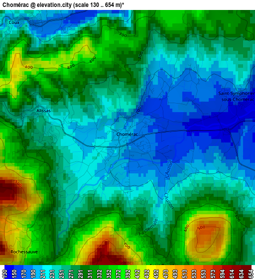
Below is the Elevation map of Chomérac, which displays elevation range with different colors. Scale of the first map is from 130 to 654 m (427 to 2146 ft) with average elevation of 284.1 meters (=932 ft) [note 1]
These maps also provides idea of topography and contour of this city, they are displayed at different zoom levels. More info about maps, scale and edge coordinates you can find below images.
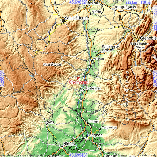
| \ | Map #1 | Topo.Map |
| Scale [m] | 130..654 m | × |
| Scale [ft] | 427..2146 ft | × |
| Average | 284.1 m = 932 ft | × |
| Width | 6.95 km = 4.3 mi | 222.3 km = 138.1 mi |
| Height | 6.95 km = 4.3 mi | 222.2 km = 138.1 mi |
| ↑Max Latitude | 44.738744° | 45.69832° |
| Latitude at center | 44.70752° | 44.70752° |
| ↓Min Latitude | 44.676279° | 43.69946° |
| ← Min Longitude | 4.617695° | 3.25539° |
| Longitude center | 4.66164° | 4.66164° |
| →Max Longitude | 4.705585° | 6.06789° |
Nearby cities:
Cities around Chomérac sort by population:
• Privas elevation 280 m
5.8 km,  301°
301°
• Loriol-sur-Drôme 185 m
13 km,  70°
70°
• Le Pouzin 94 m
8.4 km,  54°
54°
• Cruas 78 m
9.8 km,  125°
125°
• Saulce-sur-Rhône 146 m
11 km,  91°
91°
• Veyras 438 m
8.4 km,  291°
291°
• Coux 225 m
4.4 km,  313°
313°
• Saint-Priest 394 m
9.2 km,  276°
276°
• Meysse 84 m
11.9 km,  155°
155°
• Flaviac 152 m
4.6 km,  12°
12°
• Alissas 239 m
2.6 km, 282°
• Saint-Julien-en-Saint-Alban 133 m
5.9 km,  28°
28°
Multilingual:
 En español:
Chomérac elevación 198 m.
 En France:
Chomérac élévation 198 m.
 Auf Deutsch:
Chomérac höhe über dem Meeresspiegel ist 198 m.

Sources and notes:
- [note 1] Map square and city borders are not equal. Map elevation data is calculated only from area inside that square.
- [src 1] Elevation data from geonames database provided with same terms of usage.
- [src 2] The elevation map of Chomérac is generated using elevation data from NASA's 3 arcsec (90m) resolution SRTM data.
- [src 3] Base (background) map © OpenStreetMap contributors tiles are generated by Geofabrik and OpenTopoMap.
Copyright & License:
This Chomérac Elevation Map is licensed under CC BY-SA. You may reuse any part from this page, if you give a proper credit by linking to this URL:
 More info on terms of use page.