Privas elevation
Privas (Auvergne-Rhône-Alpes, Département de l'Ardèche), France elevation is 280 meters and Privas elevation in feet is 919 ft above sea level [src 1]. Privas is a seat of a second-order administrative division (feature code) with elevation that is 106 meters (348 ft) bigger than average city elevation in France.
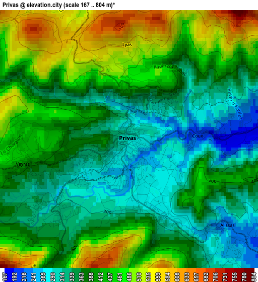
Below is the Elevation map of Privas, which displays elevation range with different colors. Scale of the first map is from 167 to 804 m (548 to 2638 ft) with average elevation of 400.5 meters (=1314 ft) [note 1]
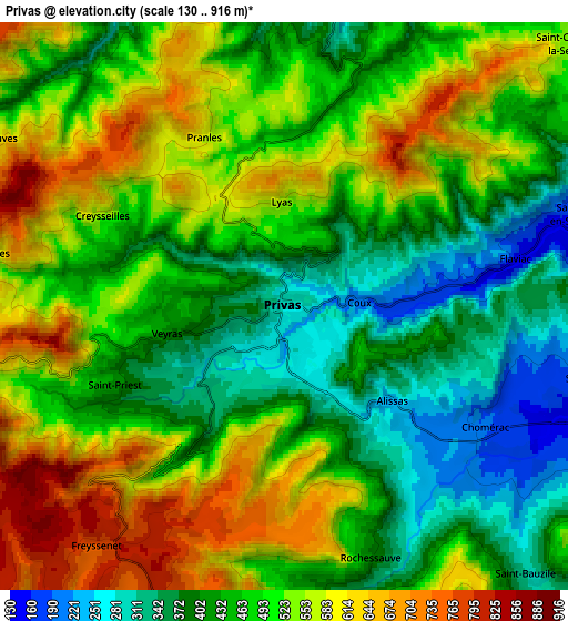
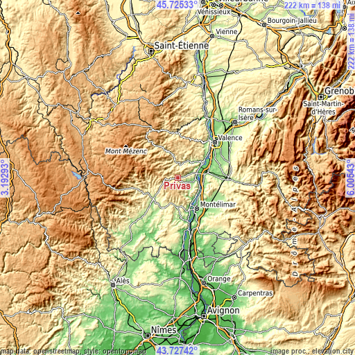
These maps also provides idea of topography and contour of this city, they are displayed at different zoom levels. More info about maps, scale and edge coordinates you can find below images.
| \ | Map #1 | Map #2 | Topo.Map |
| Scale [m] | 167..804 m | 130..916 m | × |
| Scale [ft] | 548..2638 ft | 427..3005 ft | × |
| Average | 400.5 m = 1314 ft | 487.2 m = 1598 ft | × |
| Width | 6.94 km = 4.3 mi | 13.88 km = 8.6 mi | 222.1 km = 138 mi |
| Height | 6.94 km = 4.3 mi | 13.88 km = 8.6 mi | 222.1 km = 138 mi |
| ↑Max Latitude | 44.766209° | 44.797401° | 45.72533° |
| Latitude at center | 44.735° | 44.735° | 44.735° |
| ↓Min Latitude | 44.703774° | 44.672531° | 43.72742° |
| ← Min Longitude | 4.555235° | 4.511289° | 3.19293° |
| Longitude center | 4.59918° | 4.59918° | 4.59918° |
| →Max Longitude | 4.643125° | 4.687071° | 6.00543° |
Nearby cities:
Cities around Privas sort by population:
• La Voulte-sur-Rhône elevation 93 m
15.9 km,  63°
63°
• Le Pouzin 94 m
11.9 km,  81°
81°
• Chomérac 198 m
5.8 km,  121°
121°
• Cruas 78 m
15.6 km, 123°
• Veyras 438 m
2.9 km,  270°
270°
• Coux 225 m
1.7 km,  90°
90°
• Vesseaux 294 m
15.6 km,  233°
233°
• Saint-Sauveur-de-Montagut 221 m
9.7 km,  351°
351°
• Saint-Priest 394 m
4.7 km,  243°
243°
• Flaviac 152 m
6.1 km, 76°
• Alissas 239 m
3.5 km,  136°
136°
• Saint-Julien-en-Saint-Alban 133 m
8 km,  74°
74°
Multilingual:
 En español:
Privas elevación 280 m.
 En France:
Privas élévation 280 m.


Sources and notes:
- [note 1] Map square and city borders are not equal. Map elevation data is calculated only from area inside that square.
- [src 1] Elevation data from geonames database provided with same terms of usage.
- [src 2] The elevation map of Privas is generated using elevation data from NASA's 3 arcsec (90m) resolution SRTM data.
- [src 3] Base (background) map © OpenStreetMap contributors tiles are generated by Geofabrik and OpenTopoMap.
Copyright & License:
This Privas Elevation Map is licensed under CC BY-SA. You may reuse any part from this page, if you give a proper credit by linking to this URL:
 More info on terms of use page.