Clécy elevation
Clécy (Normandy, Calvados), France elevation is 67 meters and Clécy elevation in feet is 220 ft above sea level [src 1]. Clécy is a populated place (feature code) with elevation that is 107 meters (351 ft) smaller than average city elevation in France.
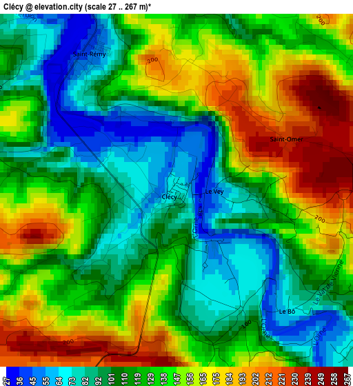
Below is the Elevation map of Clécy, which displays elevation range with different colors. Scale of the first map is from 27 to 267 m (89 to 876 ft) with average elevation of 128.8 meters (=423 ft) [note 1]
These maps also provides idea of topography and contour of this city, they are displayed at different zoom levels. More info about maps, scale and edge coordinates you can find below images.
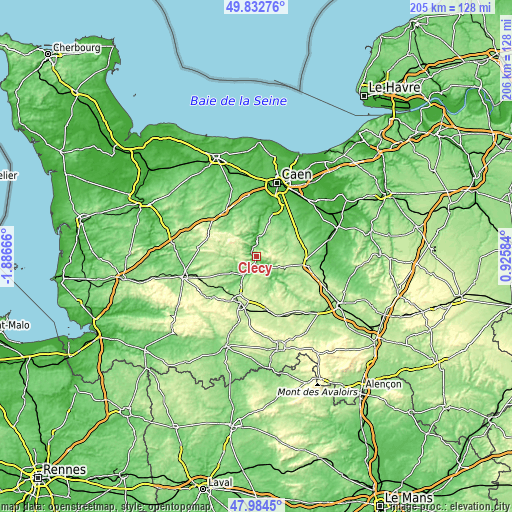
| \ | Map #1 | Topo.Map |
| Scale [m] | 27..267 m | × |
| Scale [ft] | 89..876 ft | × |
| Average | 128.8 m = 423 ft | × |
| Width | 6.42 km = 4 mi | 205.5 km = 127.7 mi |
| Height | 6.42 km = 4 mi | 205.5 km = 127.7 mi |
| ↑Max Latitude | 48.94605° | 49.83276° |
| Latitude at center | 48.91718° | 48.91718° |
| ↓Min Latitude | 48.888293° | 47.9845° |
| ← Min Longitude | -0.524355° | -1.88666° |
| Longitude center | -0.48041° | -0.48041° |
| →Max Longitude | -0.436465° | 0.92584° |
Nearby cities:
Cities around Clécy sort by population:
• Condé-sur-Noireau elevation 83 m
9.2 km,  214°
214°
• Saint-Georges-des-Groseillers 222 m
17.6 km,  201°
201°
• Aunay-sur-Odon 121 m
15.9 km,  315°
315°
• Athis-de-l'Orne 226 m
11.3 km,  187°
187°
• Le Theil-Bocage 218 m
17.7 km,  257°
257°
• Thury-Harcourt 60 m
7.5 km,  2°
2°
• Vassy 150 m
15.9 km,  243°
243°
• Bretteville-sur-Laize 57 m
18.1 km,  38°
38°
• Saint-Pierre-du-Regard 126 m
9.6 km, 210°
• Sainte-Honorine-du-Fay 116 m
17.9 km,  357°
357°
• Saint-Rémy 40 m
3.1 km,  326°
326°
• Pont-d'Ouilly 124 m
7.3 km,  128°
128°
Multilingual:
 En español:
Clécy elevación 67 m.
 En France:
Clécy élévation 67 m.


Sources and notes:
- [note 1] Map square and city borders are not equal. Map elevation data is calculated only from area inside that square.
- [src 1] Elevation data from geonames database provided with same terms of usage.
- [src 2] The elevation map of Clécy is generated using elevation data from NASA's 3 arcsec (90m) resolution SRTM data.
- [src 3] Base (background) map © OpenStreetMap contributors tiles are generated by Geofabrik and OpenTopoMap.
Copyright & License:
This Clécy Elevation Map is licensed under CC BY-SA. You may reuse any part from this page, if you give a proper credit by linking to this URL:
 More info on terms of use page.