Clerval elevation
Clerval (Bourgogne-Franche-Comté, Doubs), France elevation is 294 meters and Clerval elevation in feet is 965 ft above sea level [src 1]. Clerval is a populated place (feature code) with elevation that is 120 meters (394 ft) bigger than average city elevation in France.
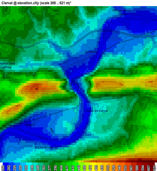
Below is the Elevation map of Clerval, which displays elevation range with different colors. Scale of the first map is from 268 to 621 m (879 to 2037 ft) with average elevation of 363.4 meters (=1192 ft) [note 1]
These maps also provides idea of topography and contour of this city, they are displayed at different zoom levels. More info about maps, scale and edge coordinates you can find below images.
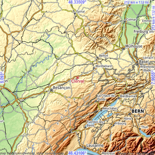
| \ | Map #1 | Topo.Map |
| Scale [m] | 268..621 m | × |
| Scale [ft] | 879..2037 ft | × |
| Average | 363.4 m = 1192 ft | × |
| Width | 6.62 km = 4.1 mi | 211.7 km = 131.5 mi |
| Height | 6.62 km = 4.1 mi | 211.7 km = 131.5 mi |
| ↑Max Latitude | 47.421412° | 48.33509° |
| Latitude at center | 47.39167° | 47.39167° |
| ↓Min Latitude | 47.361911° | 46.43106° |
| ← Min Longitude | 6.455305° | 5.093° |
| Longitude center | 6.49925° | 6.49925° |
| →Max Longitude | 6.543195° | 7.9055° |
Nearby cities:
Cities around Clerval sort by population:
• Baume-les-Dames elevation 283 m
11.3 km,  247°
247°
• Pont-de-Roide 359 m
20.3 km,  91°
91°
• Bavans 350 m
20.4 km,  59°
59°
• Mathay 339 m
22.1 km,  76°
76°
• Villersexel 280 m
18.4 km,  344°
344°
• Colombier-Fontaine 304 m
15.9 km, 64°
• Pierrefontaine-les-Varans 692 m
19.8 km,  170°
170°
• Rougemont 260 m
14.8 km,  312°
312°
• Arcey 379 m
19 km,  40°
40°
• Montenois 410 m
16.8 km,  48°
48°
• Sancey-le-Grand 503 m
12.5 km,  149°
149°
• Roulans 347 m
22 km, 247°
Multilingual:
 En español:
Clerval elevación 294 m.
 En France:
Clerval élévation 294 m.


Sources and notes:
- [note 1] Map square and city borders are not equal. Map elevation data is calculated only from area inside that square.
- [src 1] Elevation data from geonames database provided with same terms of usage.
- [src 2] The elevation map of Clerval is generated using elevation data from NASA's 3 arcsec (90m) resolution SRTM data.
- [src 3] Base (background) map © OpenStreetMap contributors tiles are generated by Geofabrik and OpenTopoMap.
Copyright & License:
This Clerval Elevation Map is licensed under CC BY-SA. You may reuse any part from this page, if you give a proper credit by linking to this URL:
 More info on terms of use page.