Bavans elevation
Bavans (Bourgogne-Franche-Comté, Doubs), France elevation is 350 meters and Bavans elevation in feet is 1148 ft above sea level [src 1]. Bavans is a populated place (feature code) with elevation that is 176 meters (577 ft) bigger than average city elevation in France.
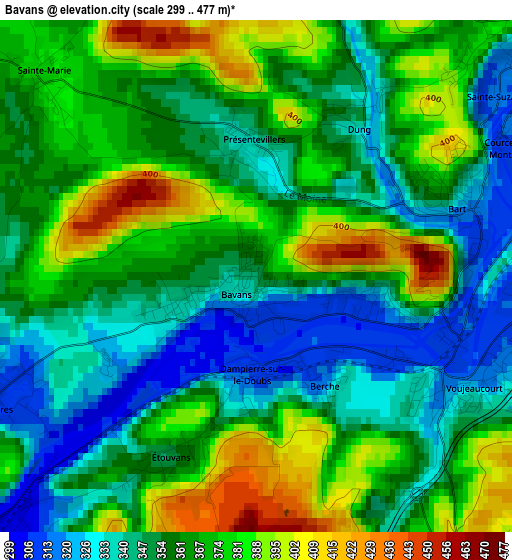
Below is the Elevation map of Bavans, which displays elevation range with different colors. Scale of the first map is from 299 to 477 m (981 to 1565 ft) with average elevation of 361.4 meters (=1186 ft) [note 1]
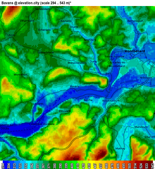
These maps also provides idea of topography and contour of this city, they are displayed at different zoom levels. More info about maps, scale and edge coordinates you can find below images.
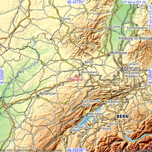
| \ | Map #1 | Map #2 | Topo.Map |
| Scale [m] | 299..477 m | 294..543 m | × |
| Scale [ft] | 981..1565 ft | 965..1781 ft | × |
| Average | 361.4 m = 1186 ft | 376.3 m = 1235 ft | × |
| Width | 6.6 km = 4.1 mi | 13.21 km = 8.2 mi | 211.3 km = 131.3 mi |
| Height | 6.6 km = 4.1 mi | 13.21 km = 8.2 mi | 211.3 km = 131.3 mi |
| ↑Max Latitude | 47.514969° | 47.544641° | 48.42701° |
| Latitude at center | 47.48528° | 47.48528° | 47.48528° |
| ↓Min Latitude | 47.455574° | 47.425852° | 46.52636° |
| ← Min Longitude | 6.689295° | 6.645349° | 5.32699° |
| Longitude center | 6.73324° | 6.73324° | 6.73324° |
| →Max Longitude | 6.777185° | 6.821131° | 8.13949° |
Nearby cities:
Cities around Bavans sort by population:
• Montbéliard elevation 321 m
5.6 km,  61°
61°
• Mandeure 330 m
6.9 km,  125°
125°
• Sochaux 324 m
7.5 km,  70°
70°
• Voujeaucourt 316 m
3.3 km,  110°
110°
• Mathay 339 m
6.4 km,  142°
142°
• Bart 312 m
2.9 km,  82°
82°
• Colombier-Fontaine 304 m
4.9 km,  221°
221°
• Sainte-Suzanne 407 m
3.1 km, 57°
• Arcey 379 m
6.8 km,  307°
307°
• Montenois 410 m
5.1 km,  278°
278°
• Courcelles-lès-Montbéliard 341 m
4.2 km, 65°
• Arbouans 347 m
4.9 km, 71°
Multilingual:
 En español:
Bavans elevación 350 m.
 En France:
Bavans élévation 350 m.


Sources and notes:
- [note 1] Map square and city borders are not equal. Map elevation data is calculated only from area inside that square.
- [src 1] Elevation data from geonames database provided with same terms of usage.
- [src 2] The elevation map of Bavans is generated using elevation data from NASA's 3 arcsec (90m) resolution SRTM data.
- [src 3] Base (background) map © OpenStreetMap contributors tiles are generated by Geofabrik and OpenTopoMap.
Copyright & License:
This Bavans Elevation Map is licensed under CC BY-SA. You may reuse any part from this page, if you give a proper credit by linking to this URL:
 More info on terms of use page.