Cormontreuil elevation
Cormontreuil (Grand Est, Marne), France elevation is 91 meters and Cormontreuil elevation in feet is 299 ft above sea level [src 1]. Cormontreuil is a populated place (feature code) with elevation that is 83 meters (272 ft) smaller than average city elevation in France.
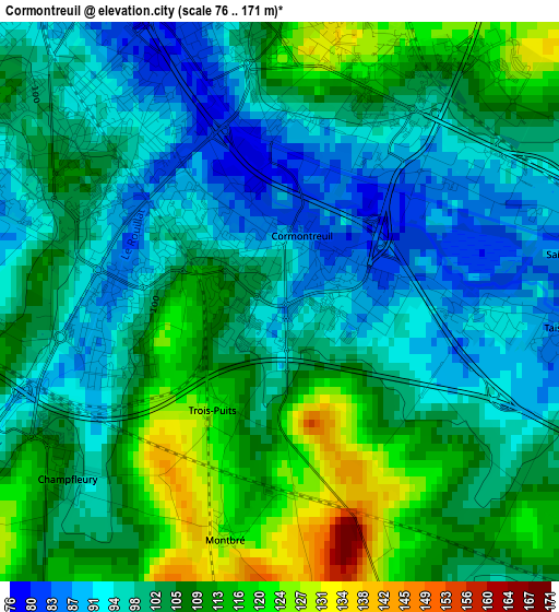
Below is the Elevation map of Cormontreuil, which displays elevation range with different colors. Scale of the first map is from 76 to 171 m (249 to 561 ft) with average elevation of 102.6 meters (=337 ft) [note 1]
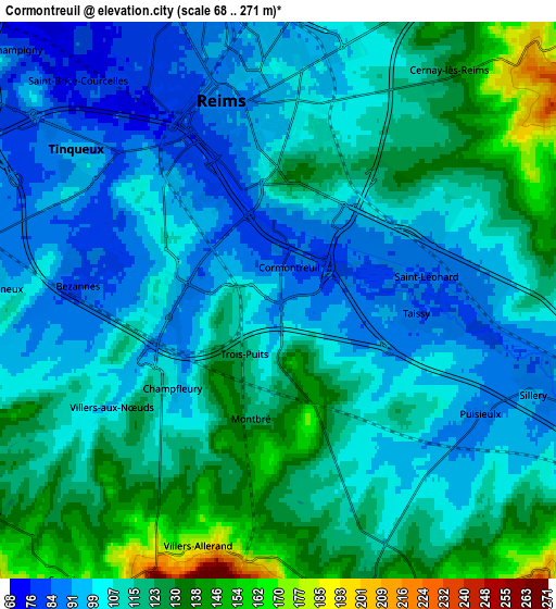
These maps also provides idea of topography and contour of this city, they are displayed at different zoom levels. More info about maps, scale and edge coordinates you can find below images.
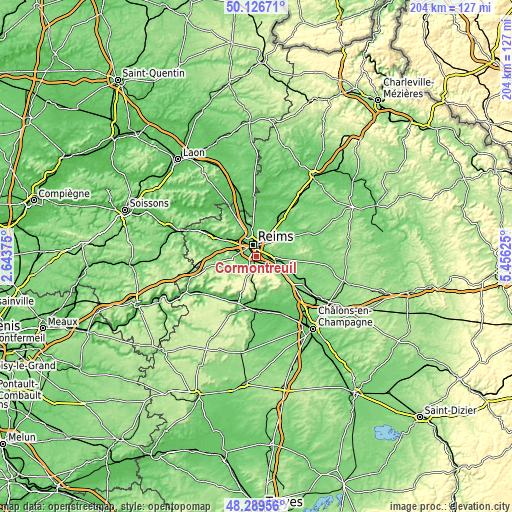
| \ | Map #1 | Map #2 | Topo.Map |
| Scale [m] | 76..171 m | 68..271 m | × |
| Scale [ft] | 249..561 ft | 223..889 ft | × |
| Average | 102.6 m = 337 ft | 111.2 m = 365 ft | × |
| Width | 6.38 km = 4 mi | 12.77 km = 7.9 mi | 204.3 km = 126.9 mi |
| Height | 6.38 km = 4 mi | 12.77 km = 7.9 mi | 204.3 km = 126.9 mi |
| ↑Max Latitude | 49.245367° | 49.274047° | 50.12671° |
| Latitude at center | 49.21667° | 49.21667° | 49.21667° |
| ↓Min Latitude | 49.187957° | 49.159226° | 48.28956° |
| ← Min Longitude | 4.006055° | 3.962109° | 2.64375° |
| Longitude center | 4.05° | 4.05° | 4.05° |
| →Max Longitude | 4.093945° | 4.137891° | 5.45625° |
Nearby cities:
Cities around Cormontreuil sort by population:
• Reims elevation 90 m
5.6 km,  343°
343°
• Tinqueux 90 m
6.1 km,  307°
307°
• Bétheny 91 m
7.6 km,  2°
2°
• Witry-lès-Reims 130 m
9.7 km,  31°
31°
• Saint-Brice-Courcelles 73 m
7.4 km,  318°
318°
• Taissy 82 m
3.2 km,  93°
93°
• Sillery 89 m
6.3 km,  108°
108°
• Gueux 96 m
10.8 km,  290°
290°
• Bezannes 81 m
4.5 km,  279°
279°
• Cernay-lès-Reims 128 m
6.5 km,  35°
35°
• Verzenay 175 m
9.4 km,  132°
132°
• Rilly-la-Montagne 156 m
5.7 km,  183°
183°
Multilingual:
 En español:
Cormontreuil elevación 91 m.
 En France:
Cormontreuil élévation 91 m.
 Auf Deutsch:
Cormontreuil höhe über dem Meeresspiegel ist 91 m.

Sources and notes:
- [note 1] Map square and city borders are not equal. Map elevation data is calculated only from area inside that square.
- [src 1] Elevation data from geonames database provided with same terms of usage.
- [src 2] The elevation map of Cormontreuil is generated using elevation data from NASA's 3 arcsec (90m) resolution SRTM data.
- [src 3] Base (background) map © OpenStreetMap contributors tiles are generated by Geofabrik and OpenTopoMap.
Copyright & License:
This Cormontreuil Elevation Map is licensed under CC BY-SA. You may reuse any part from this page, if you give a proper credit by linking to this URL:
 More info on terms of use page.