Courtenay elevation
Courtenay (Centre, Loiret), France elevation is 170 meters and Courtenay elevation in feet is 558 ft above sea level [src 1]. Courtenay is a populated place (feature code) with elevation that is 4 meters (13 ft) smaller than average city elevation in France.
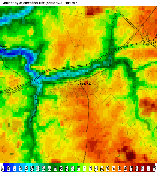
Below is the Elevation map of Courtenay, which displays elevation range with different colors. Scale of the first map is from 130 to 191 m (427 to 627 ft) with average elevation of 165.1 meters (=542 ft) [note 1]
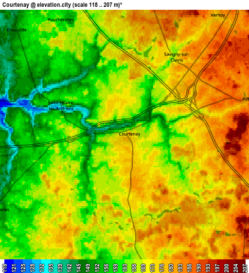
These maps also provides idea of topography and contour of this city, they are displayed at different zoom levels. More info about maps, scale and edge coordinates you can find below images.
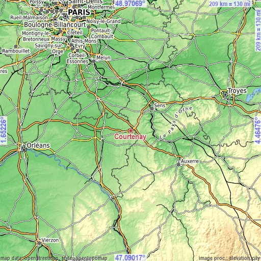
| \ | Map #1 | Map #2 | Topo.Map |
| Scale [m] | 130..191 m | 118..207 m | × |
| Scale [ft] | 427..627 ft | 387..679 ft | × |
| Average | 165.1 m = 542 ft | 168.8 m = 554 ft | × |
| Width | 6.53 km = 4.1 mi | 13.07 km = 8.1 mi | 209.1 km = 129.9 mi |
| Height | 6.53 km = 4.1 mi | 13.07 km = 8.1 mi | 209.1 km = 129.9 mi |
| ↑Max Latitude | 48.068385° | 48.097742° | 48.97069° |
| Latitude at center | 48.03901° | 48.03901° | 48.03901° |
| ↓Min Latitude | 48.009619° | 47.980211° | 47.09017° |
| ← Min Longitude | 3.014565° | 2.970619° | 1.65226° |
| Longitude center | 3.05851° | 3.05851° | 3.05851° |
| →Max Longitude | 3.102455° | 3.146401° | 4.46476° |
Nearby cities:
Cities around Courtenay sort by population:
• Villeneuve-sur-Yonne elevation 80 m
18.4 km,  74°
74°
• Saint-Julien-du-Sault 90 m
17.6 km,  92°
92°
• Château-Renard 116 m
15 km,  218°
218°
• Égreville 123 m
20.6 km,  317°
317°
• Saint-Germain-des-Prés 116 m
18.3 km,  238°
238°
• Charny 136 m
17.2 km,  170°
170°
• Saint-Valérien 166 m
15.7 km,  10°
10°
• Chéroy 151 m
18.5 km,  346°
346°
• Gron 81 m
20.3 km,  48°
48°
• Triguères 120 m
12.3 km,  206°
206°
• Douchy 127 m
10.7 km,  181°
181°
• Égriselles-le-Bocage 182 m
13 km, 45°
Multilingual:
 En español:
Courtenay elevación 170 m.
 En France:
Courtenay élévation 170 m.
 Auf Deutsch:
Courtenay höhe über dem Meeresspiegel ist 170 m.

Sources and notes:
- [note 1] Map square and city borders are not equal. Map elevation data is calculated only from area inside that square.
- [src 1] Elevation data from geonames database provided with same terms of usage.
- [src 2] The elevation map of Courtenay is generated using elevation data from NASA's 3 arcsec (90m) resolution SRTM data.
- [src 3] Base (background) map © OpenStreetMap contributors tiles are generated by Geofabrik and OpenTopoMap.
Copyright & License:
This Courtenay Elevation Map is licensed under CC BY-SA. You may reuse any part from this page, if you give a proper credit by linking to this URL:
 More info on terms of use page.