Crécy-sur-Serre elevation
Crécy-sur-Serre (Hauts-de-France, Département de l'Aisne), France elevation is 67 meters and Crécy-sur-Serre elevation in feet is 220 ft above sea level [src 1]. Crécy-sur-Serre is a populated place (feature code) with elevation that is 107 meters (351 ft) smaller than average city elevation in France.
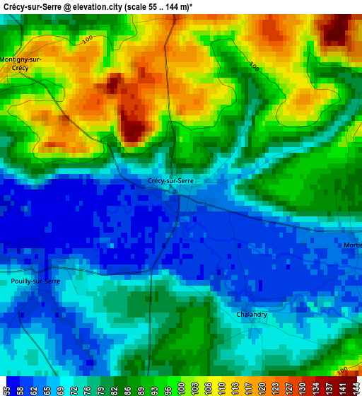
Below is the Elevation map of Crécy-sur-Serre, which displays elevation range with different colors. Scale of the first map is from 55 to 144 m (180 to 472 ft) with average elevation of 83.3 meters (=273 ft) [note 1]
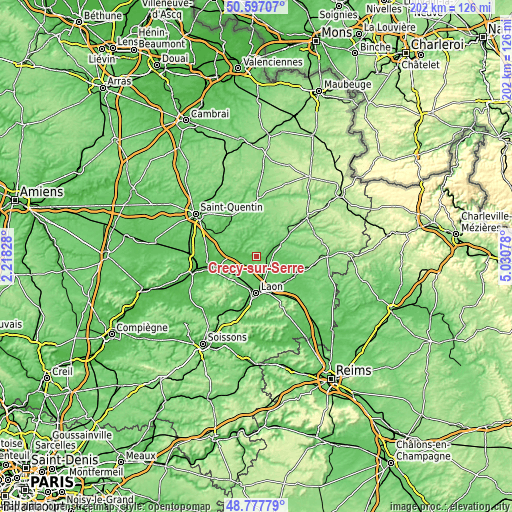
These maps also provides idea of topography and contour of this city, they are displayed at different zoom levels. More info about maps, scale and edge coordinates you can find below images.
| \ | Map #1 | Topo.Map |
| Scale [m] | 55..144 m | × |
| Scale [ft] | 180..472 ft | × |
| Average | 83.3 m = 273 ft | × |
| Width | 6.32 km = 3.9 mi | 202.3 km = 125.7 mi |
| Height | 6.32 km = 3.9 mi | 202.3 km = 125.7 mi |
| ↑Max Latitude | 49.724357° | 50.59707° |
| Latitude at center | 49.69594° | 49.69594° |
| ↓Min Latitude | 49.667506° | 48.77779° |
| ← Min Longitude | 3.580585° | 2.21828° |
| Longitude center | 3.62453° | 3.62453° |
| →Max Longitude | 3.668475° | 5.03078° |
Nearby cities:
Cities around Crécy-sur-Serre sort by population:
• Laon elevation 76 m
14.8 km,  179°
179°
• La Fère 52 m
18.9 km,  258°
258°
• Marle 109 m
11.6 km,  64°
64°
• Athies-sous-Laon 72 m
14.3 km,  162°
162°
• Ribemont 83 m
16.2 km,  312°
312°
• Charmes 55 m
18.3 km, 255°
• Origny-Sainte-Benoite 106 m
17.7 km,  329°
329°
• Crépy 85 m
13.2 km,  216°
216°
• Couvron-et-Aumencourt 77 m
9.5 km,  233°
233°
• Bruyères-et-Montbérault 86 m
19.2 km,  171°
171°
• Liesse-Notre-Dame 70 m
15.4 km,  124°
124°
• Aulnois-sous-Laon 68 m
9.2 km,  188°
188°
Multilingual:
 En español:
Crécy-sur-Serre elevación 67 m.
 En France:
Crécy-sur-Serre élévation 67 m.
 Auf Deutsch:
Crécy-sur-Serre höhe über dem Meeresspiegel ist 67 m.

Sources and notes:
- [note 1] Map square and city borders are not equal. Map elevation data is calculated only from area inside that square.
- [src 1] Elevation data from geonames database provided with same terms of usage.
- [src 2] The elevation map of Crécy-sur-Serre is generated using elevation data from NASA's 3 arcsec (90m) resolution SRTM data.
- [src 3] Base (background) map © OpenStreetMap contributors tiles are generated by Geofabrik and OpenTopoMap.
Copyright & License:
This Crécy-sur-Serre Elevation Map is licensed under CC BY-SA. You may reuse any part from this page, if you give a proper credit by linking to this URL:
 More info on terms of use page.