La Fère elevation
La Fère (Hauts-de-France, Département de l'Aisne), France elevation is 52 meters and La Fère elevation in feet is 171 ft above sea level [src 1]. La Fère is a populated place (feature code) with elevation that is 122 meters (400 ft) smaller than average city elevation in France.
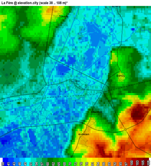
Below is the Elevation map of La Fère, which displays elevation range with different colors. Scale of the first map is from 38 to 108 m (125 to 354 ft) with average elevation of 59.4 meters (=195 ft) [note 1]
These maps also provides idea of topography and contour of this city, they are displayed at different zoom levels. More info about maps, scale and edge coordinates you can find below images.
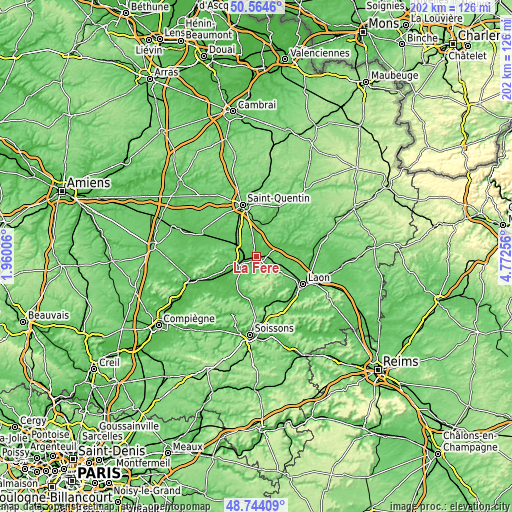
| \ | Map #1 | Topo.Map |
| Scale [m] | 38..108 m | × |
| Scale [ft] | 125..354 ft | × |
| Average | 59.4 m = 195 ft | × |
| Width | 6.33 km = 3.9 mi | 202.4 km = 125.8 mi |
| Height | 6.33 km = 3.9 mi | 202.4 km = 125.8 mi |
| ↑Max Latitude | 49.691297° | 50.5646° |
| Latitude at center | 49.66286° | 49.66286° |
| ↓Min Latitude | 49.634407° | 48.74409° |
| ← Min Longitude | 3.322365° | 1.96006° |
| Longitude center | 3.36631° | 3.36631° |
| →Max Longitude | 3.410255° | 4.77256° |
Nearby cities:
Cities around La Fère sort by population:
• Tergnier elevation 55 m
4.8 km,  260°
260°
• Chauny 49 m
11.9 km,  243°
243°
• Beautor 51 m
2 km,  232°
232°
• Saint-Gobain 174 m
7.5 km,  173°
173°
• Sinceny 71 m
11.4 km, 229°
• Viry-Noureuil 54 m
9.5 km,  248°
248°
• Charmes 55 m
1.4 km,  139°
139°
• Crépy 85 m
12.9 km,  122°
122°
• Couvron-et-Aumencourt 77 m
11.1 km,  100°
100°
• Montescourt-Lizerolles 76 m
11.5 km,  316°
316°
• Jussy 72 m
11.5 km,  303°
303°
• Ognes 57 m
13.7 km, 245°
Multilingual:
 En español:
La Fère elevación 52 m.
 En France:
La Fère élévation 52 m.


Sources and notes:
- [note 1] Map square and city borders are not equal. Map elevation data is calculated only from area inside that square.
- [src 1] Elevation data from geonames database provided with same terms of usage.
- [src 2] The elevation map of La Fère is generated using elevation data from NASA's 3 arcsec (90m) resolution SRTM data.
- [src 3] Base (background) map © OpenStreetMap contributors tiles are generated by Geofabrik and OpenTopoMap.
Copyright & License:
This La Fère Elevation Map is licensed under CC BY-SA. You may reuse any part from this page, if you give a proper credit by linking to this URL:
 More info on terms of use page.