Crédin elevation
Crédin (Brittany, Morbihan), France elevation is 130 meters and Crédin elevation in feet is 427 ft above sea level [src 1]. Crédin is a populated place (feature code) with elevation that is 44 meters (144 ft) smaller than average city elevation in France.
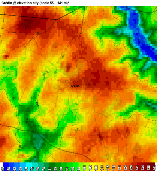
Below is the Elevation map of Crédin, which displays elevation range with different colors. Scale of the first map is from 55 to 141 m (180 to 463 ft) with average elevation of 109.7 meters (=360 ft) [note 1]
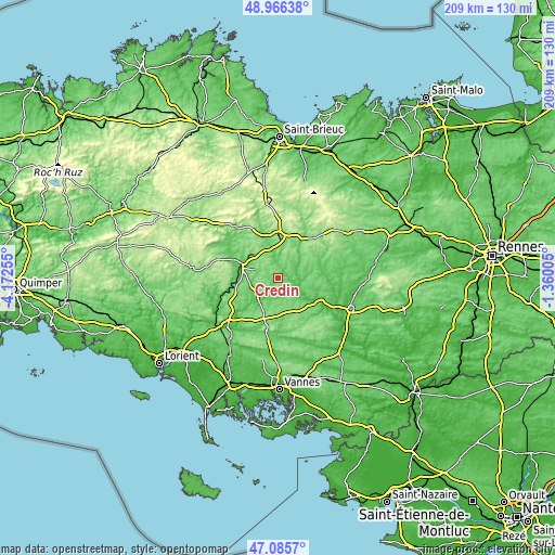
These maps also provides idea of topography and contour of this city, they are displayed at different zoom levels. More info about maps, scale and edge coordinates you can find below images.
| \ | Map #1 | Topo.Map |
| Scale [m] | 55..141 m | × |
| Scale [ft] | 180..463 ft | × |
| Average | 109.7 m = 360 ft | × |
| Width | 6.53 km = 4.1 mi | 209.1 km = 129.9 mi |
| Height | 6.53 km = 4.1 mi | 209.1 km = 129.9 mi |
| ↑Max Latitude | 48.063997° | 48.96638° |
| Latitude at center | 48.03462° | 48.03462° |
| ↓Min Latitude | 48.005226° | 47.0857° |
| ← Min Longitude | -2.810245° | -4.17255° |
| Longitude center | -2.7663° | -2.7663° |
| →Max Longitude | -2.722355° | -1.36005° |
Nearby cities:
Cities around Crédin sort by population:
• Pontivy elevation 95 m
15.1 km,  284°
284°
• Noyal-Pontivy 137 m
9.4 km,  292°
292°
• Moréac 116 m
13.4 km,  197°
197°
• Saint-Thuriau 102 m
13.8 km,  261°
261°
• Réguiny 114 m
6.7 km,  166°
166°
• Rohan 67 m
3.9 km,  16°
16°
• Lanouée 93 m
14.2 km,  104°
104°
• Naizin 122 m
7 km,  224°
224°
• Saint-Barnabé 143 m
12.3 km, 21°
• Pleugriffet 107 m
8.1 km,  131°
131°
• Plumieux 131 m
15.5 km,  60°
60°
• Saint-Gonnery 130 m
10.7 km,  338°
338°
Multilingual:
 En español:
Crédin elevación 130 m.
 En France:
Crédin élévation 130 m.


Sources and notes:
- [note 1] Map square and city borders are not equal. Map elevation data is calculated only from area inside that square.
- [src 1] Elevation data from geonames database provided with same terms of usage.
- [src 2] The elevation map of Crédin is generated using elevation data from NASA's 3 arcsec (90m) resolution SRTM data.
- [src 3] Base (background) map © OpenStreetMap contributors tiles are generated by Geofabrik and OpenTopoMap.
Copyright & License:
This Crédin Elevation Map is licensed under CC BY-SA. You may reuse any part from this page, if you give a proper credit by linking to this URL:
 More info on terms of use page.