Pontivy elevation
Pontivy (Brittany, Morbihan), France elevation is 95 meters and Pontivy elevation in feet is 312 ft above sea level [src 1]. Pontivy is a seat of a third-order administrative division (feature code) with elevation that is 79 meters (259 ft) smaller than average city elevation in France.
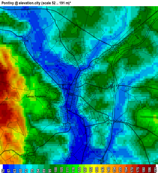
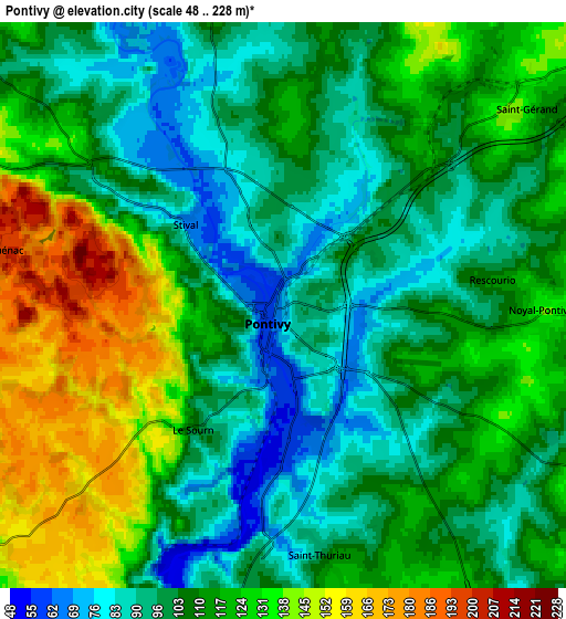
Below is the Elevation map of Pontivy, which displays elevation range with different colors. Scale of the first map is from 52 to 191 m (171 to 627 ft) with average elevation of 91.2 meters (=299 ft) [note 1]
These maps also provides idea of topography and contour of this city, they are displayed at different zoom levels. More info about maps, scale and edge coordinates you can find below images.
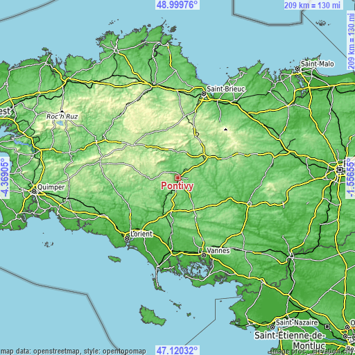
| \ | Map #1 | Map #2 | Topo.Map |
| Scale [m] | 52..191 m | 48..228 m | × |
| Scale [ft] | 171..627 ft | 157..748 ft | × |
| Average | 91.2 m = 299 ft | 112 m = 367 ft | × |
| Width | 6.53 km = 4.1 mi | 13.06 km = 8.1 mi | 209 km = 129.9 mi |
| Height | 6.53 km = 4.1 mi | 13.06 km = 8.1 mi | 209 km = 129.9 mi |
| ↑Max Latitude | 48.097978° | 48.127319° | 48.99976° |
| Latitude at center | 48.06862° | 48.06862° | 48.06862° |
| ↓Min Latitude | 48.039246° | 48.009854° | 47.12032° |
| ← Min Longitude | -3.006745° | -3.050691° | -4.36905° |
| Longitude center | -2.9628° | -2.9628° | -2.9628° |
| →Max Longitude | -2.918855° | -2.874909° | -1.55655° |
Nearby cities:
Cities around Pontivy sort by population:
• Noyal-Pontivy elevation 137 m
5.9 km,  92°
92°
• Pluméliau 117 m
12.4 km,  184°
184°
• Cléguérec 156 m
10.3 km,  308°
308°
• Mûr-de-Bretagne 140 m
14.7 km,  354°
354°
• Le Sourn 100 m
3.4 km,  212°
212°
• Saint-Thuriau 102 m
5.9 km,  170°
170°
• Malguénac 200 m
6.8 km,  280°
280°
• Melrand 68 m
14.7 km,  227°
227°
• Naizin 122 m
13 km,  132°
132°
• Neulliac 118 m
6.8 km, 347°
• Guern 140 m
10.5 km,  245°
245°
• Saint-Gonnery 130 m
12.4 km,  59°
59°
Multilingual:
 En español:
Pontivy elevación 95 m.
 En France:
Pontivy élévation 95 m.


Sources and notes:
- [note 1] Map square and city borders are not equal. Map elevation data is calculated only from area inside that square.
- [src 1] Elevation data from geonames database provided with same terms of usage.
- [src 2] The elevation map of Pontivy is generated using elevation data from NASA's 3 arcsec (90m) resolution SRTM data.
- [src 3] Base (background) map © OpenStreetMap contributors tiles are generated by Geofabrik and OpenTopoMap.
Copyright & License:
This Pontivy Elevation Map is licensed under CC BY-SA. You may reuse any part from this page, if you give a proper credit by linking to this URL:
 More info on terms of use page.