Cugnaux elevation
Cugnaux (Occitanie, Haute-Garonne), France elevation is 170 meters and Cugnaux elevation in feet is 558 ft above sea level [src 1]. Cugnaux is a populated place (feature code) with elevation that is 4 meters (13 ft) smaller than average city elevation in France.
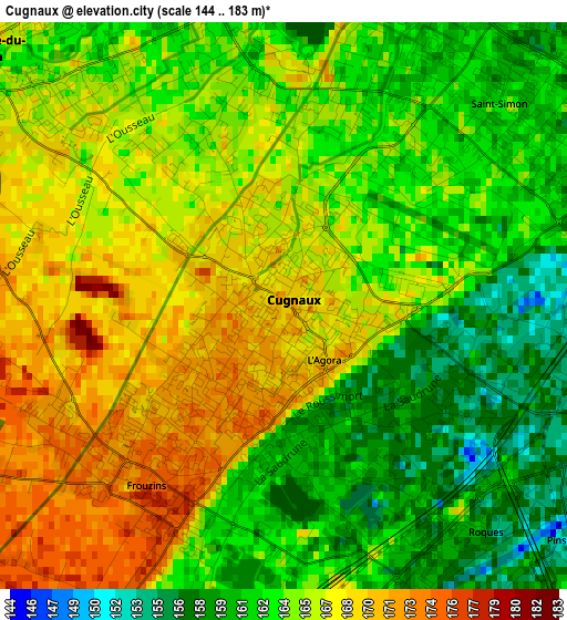
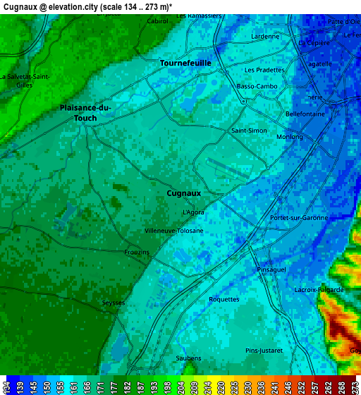
Below is the Elevation map of Cugnaux, which displays elevation range with different colors. Scale of the first map is from 144 to 183 m (472 to 600 ft) with average elevation of 164.3 meters (=539 ft) [note 1]
These maps also provides idea of topography and contour of this city, they are displayed at different zoom levels. More info about maps, scale and edge coordinates you can find below images.
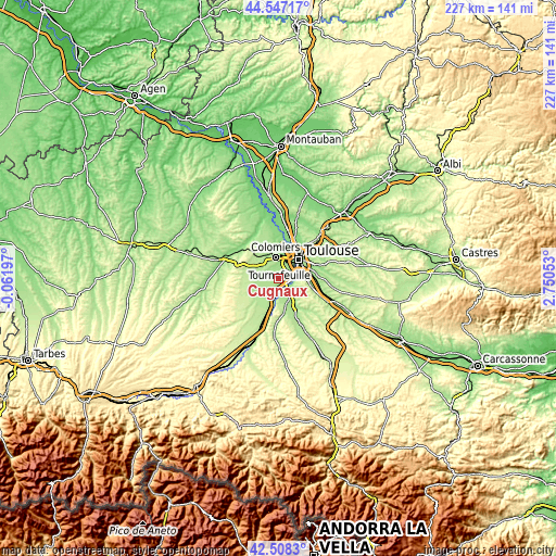
| \ | Map #1 | Map #2 | Topo.Map |
| Scale [m] | 144..183 m | 134..273 m | × |
| Scale [ft] | 472..600 ft | 440..896 ft | × |
| Average | 164.3 m = 539 ft | 166.7 m = 547 ft | × |
| Width | 7.08 km = 4.4 mi | 14.17 km = 8.8 mi | 226.7 km = 140.9 mi |
| Height | 7.08 km = 4.4 mi | 14.17 km = 8.8 mi | 226.7 km = 140.9 mi |
| ↑Max Latitude | 43.568199° | 43.600032° | 44.54717° |
| Latitude at center | 43.53635° | 43.53635° | 43.53635° |
| ↓Min Latitude | 43.504484° | 43.472601° | 42.5083° |
| ← Min Longitude | 1.300335° | 1.256389° | -0.06197° |
| Longitude center | 1.34428° | 1.34428° | 1.34428° |
| →Max Longitude | 1.388225° | 1.432171° | 2.75053° |
Nearby cities:
Cities around Cugnaux sort by population:
• Tournefeuille elevation 189 m
6.2 km,  340°
340°
• Plaisance-du-Touch 168 m
5 km,  310°
310°
• Portet-sur-Garonne 153 m
5.2 km,  106°
106°
• Villeneuve-Tolosane 173 m
1.5 km,  190°
190°
• Seysses 179 m
5 km,  212°
212°
• Frouzins 176 m
2.8 km, 212°
• La Salvetat-Saint-Gilles 191 m
7.3 km, 307°
• Roquettes 159 m
4.8 km,  155°
155°
• Pinsaguel 154 m
4.6 km,  129°
129°
• Lacroix-Falgarde 157 m
6.7 km, 127°
• Saubens 164 m
6.3 km,  174°
174°
• Vieille-Toulouse 220 m
8 km,  100°
100°
Multilingual:
 En español:
Cugnaux elevación 170 m.
 En France:
Cugnaux élévation 170 m.


Sources and notes:
- [note 1] Map square and city borders are not equal. Map elevation data is calculated only from area inside that square.
- [src 1] Elevation data from geonames database provided with same terms of usage.
- [src 2] The elevation map of Cugnaux is generated using elevation data from NASA's 3 arcsec (90m) resolution SRTM data.
- [src 3] Base (background) map © OpenStreetMap contributors tiles are generated by Geofabrik and OpenTopoMap.
Copyright & License:
This Cugnaux Elevation Map is licensed under CC BY-SA. You may reuse any part from this page, if you give a proper credit by linking to this URL:
 More info on terms of use page.