Cunlhat elevation
Cunlhat (Auvergne-Rhône-Alpes, Département du Puy-de-Dôme), France elevation is 724 meters and Cunlhat elevation in feet is 2375 ft above sea level [src 1]. Cunlhat is a populated place (feature code) with elevation that is 550 meters (1804 ft) bigger than average city elevation in France.
Below is the Elevation map of Cunlhat, which displays elevation range with different colors. Scale of the first map is from 553 to 1025 m (1814 to 3363 ft) with average elevation of 757.4 meters (=2485 ft) [note 1]
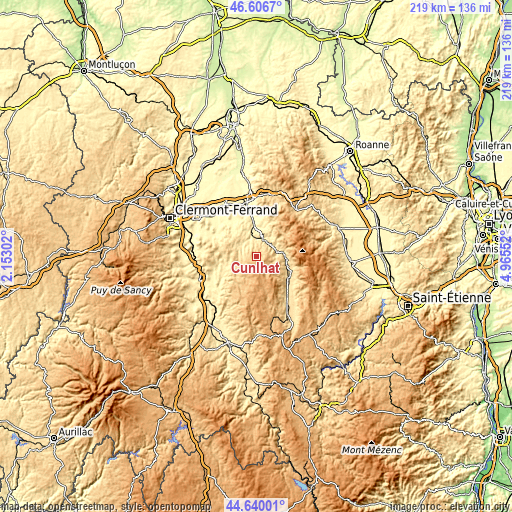
These maps also provides idea of topography and contour of this city, they are displayed at different zoom levels. More info about maps, scale and edge coordinates you can find below images.
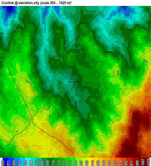
| \ | Map #1 | Topo.Map |
| Scale [m] | 553..1025 m | × |
| Scale [ft] | 1814..3363 ft | × |
| Average | 757.4 m = 2485 ft | × |
| Width | 6.83 km = 4.2 mi | 218.7 km = 135.9 mi |
| Height | 6.83 km = 4.2 mi | 218.7 km = 135.9 mi |
| ↑Max Latitude | 45.662701° | 46.6067° |
| Latitude at center | 45.63198° | 45.63198° |
| ↓Min Latitude | 45.601242° | 44.64001° |
| ← Min Longitude | 3.515325° | 2.15302° |
| Longitude center | 3.55927° | 3.55927° |
| →Max Longitude | 3.603215° | 4.96552° |
Nearby cities:
Cities around Cunlhat sort by population:
• Thiers elevation 424 m
25 km,  357°
357°
• Ambert 542 m
16.9 km,  122°
122°
• Courpière 317 m
14 km,  354°
354°
• Vic-le-Comte 484 m
24.4 km,  272°
272°
• Billom 384 m
19.9 km,  300°
300°
• Peschadoires 299 m
22.2 km, 346°
• Chauriat 395 m
25.5 km, 301°
• Marsac-en-Livradois 544 m
21.5 km,  142°
142°
• Montaigut 641 m
8.8 km,  257°
257°
• Escoutoux 490 m
20.8 km,  0°
0°
• Sauxillanges 467 m
17.2 km,  238°
238°
• Job 678 m
14.6 km,  96°
96°
Multilingual:
 En español:
Cunlhat elevación 724 m.
 En France:
Cunlhat élévation 724 m.


Sources and notes:
- [note 1] Map square and city borders are not equal. Map elevation data is calculated only from area inside that square.
- [src 1] Elevation data from geonames database provided with same terms of usage.
- [src 2] The elevation map of Cunlhat is generated using elevation data from NASA's 3 arcsec (90m) resolution SRTM data.
- [src 3] Base (background) map © OpenStreetMap contributors tiles are generated by Geofabrik and OpenTopoMap.
Copyright & License:
This Cunlhat Elevation Map is licensed under CC BY-SA. You may reuse any part from this page, if you give a proper credit by linking to this URL:
 More info on terms of use page.