Thiers elevation
Thiers (Auvergne-Rhône-Alpes, Département du Puy-de-Dôme), France elevation is 424 meters and Thiers elevation in feet is 1391 ft above sea level [src 1]. Thiers is a seat of a third-order administrative division (feature code) with elevation that is 250 meters (820 ft) bigger than average city elevation in France.
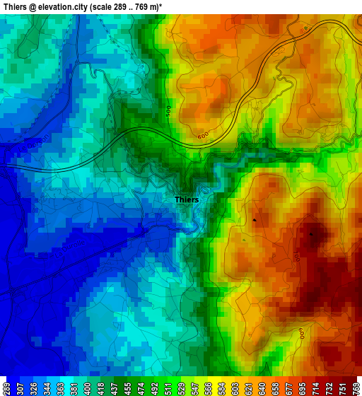
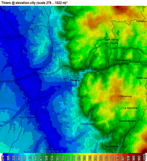
Below is the Elevation map of Thiers, which displays elevation range with different colors. Scale of the first map is from 289 to 769 m (948 to 2523 ft) with average elevation of 478 meters (=1568 ft) [note 1]
These maps also provides idea of topography and contour of this city, they are displayed at different zoom levels. More info about maps, scale and edge coordinates you can find below images.
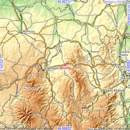
| \ | Map #1 | Map #2 | Topo.Map |
| Scale [m] | 289..769 m | 276..1022 m | × |
| Scale [ft] | 948..2523 ft | 906..3353 ft | × |
| Average | 478 m = 1568 ft | 487 m = 1598 ft | × |
| Width | 6.81 km = 4.2 mi | 13.61 km = 8.5 mi | 217.8 km = 135.3 mi |
| Height | 6.81 km = 4.2 mi | 13.61 km = 8.5 mi | 217.8 km = 135.3 mi |
| ↑Max Latitude | 45.887138° | 45.917718° | 46.82731° |
| Latitude at center | 45.85654° | 45.85654° | 45.85654° |
| ↓Min Latitude | 45.825926° | 45.795294° | 44.86852° |
| ← Min Longitude | 3.503635° | 3.459689° | 2.14133° |
| Longitude center | 3.54758° | 3.54758° | 3.54758° |
| →Max Longitude | 3.591525° | 3.635471° | 4.95383° |
Nearby cities:
Cities around Thiers sort by population:
• Lezoux elevation 360 m
13.4 km,  255°
255°
• Courpière 317 m
11.1 km,  182°
182°
• Puy-Guillaume 282 m
12.9 km,  333°
333°
• La Monnerie-le-Montel 583 m
4.4 km,  68°
68°
• Peschadoires 299 m
5.4 km,  231°
231°
• Celles-sur-Durolle 671 m
6.8 km,  88°
88°
• Orléat 356 m
9.8 km,  272°
272°
• Saint-Rémy-sur-Durolle 653 m
4.9 km,  44°
44°
• Paslières 388 m
8.9 km, 334°
• Chabreloche 642 m
11.8 km,  77°
77°
• Escoutoux 490 m
4.3 km,  163°
163°
• Culhat 300 m
16.3 km, 272°
Multilingual:
 En español:
Thiers elevación 424 m.
 En France:
Thiers élévation 424 m.


Sources and notes:
- [note 1] Map square and city borders are not equal. Map elevation data is calculated only from area inside that square.
- [src 1] Elevation data from geonames database provided with same terms of usage.
- [src 2] The elevation map of Thiers is generated using elevation data from NASA's 3 arcsec (90m) resolution SRTM data.
- [src 3] Base (background) map © OpenStreetMap contributors tiles are generated by Geofabrik and OpenTopoMap.
Copyright & License:
This Thiers Elevation Map is licensed under CC BY-SA. You may reuse any part from this page, if you give a proper credit by linking to this URL:
 More info on terms of use page.