Puy-Guillaume elevation
Puy-Guillaume (Auvergne-Rhône-Alpes, Département du Puy-de-Dôme), France elevation is 282 meters and Puy-Guillaume elevation in feet is 925 ft above sea level [src 1]. Puy-Guillaume is a populated place (feature code) with elevation that is 108 meters (354 ft) bigger than average city elevation in France.
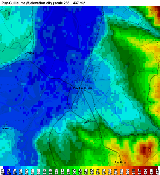
Below is the Elevation map of Puy-Guillaume, which displays elevation range with different colors. Scale of the first map is from 266 to 437 m (873 to 1434 ft) with average elevation of 302.5 meters (=992 ft) [note 1]
These maps also provides idea of topography and contour of this city, they are displayed at different zoom levels. More info about maps, scale and edge coordinates you can find below images.
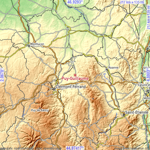
| \ | Map #1 | Topo.Map |
| Scale [m] | 266..437 m | × |
| Scale [ft] | 873..1434 ft | × |
| Average | 302.5 m = 992 ft | × |
| Width | 6.79 km = 4.2 mi | 217.4 km = 135.1 mi |
| Height | 6.79 km = 4.2 mi | 217.4 km = 135.1 mi |
| ↑Max Latitude | 45.9909° | 46.9293° |
| Latitude at center | 45.96036° | 45.96036° |
| ↓Min Latitude | 45.929803° | 44.97417° |
| ← Min Longitude | 3.430105° | 2.0678° |
| Longitude center | 3.47405° | 3.47405° |
| →Max Longitude | 3.517995° | 4.8803° |
Nearby cities:
Cities around Puy-Guillaume sort by population:
• Thiers elevation 424 m
12.9 km,  153°
153°
• Saint-Yorre 288 m
11.8 km,  356°
356°
• Maringues 308 m
11.9 km,  248°
248°
• La Monnerie-le-Montel 583 m
14 km,  135°
135°
• Peschadoires 299 m
15 km,  174°
174°
• Orléat 356 m
11.8 km,  200°
200°
• Saint-Rémy-sur-Durolle 653 m
12.2 km,  131°
131°
• Randan 392 m
11.2 km,  304°
304°
• Paslières 388 m
3.9 km, 152°
• Pragoulin 330 m
12.2 km,  329°
329°
• Hauterive 259 m
14.4 km,  351°
351°
• Culhat 300 m
15.2 km,  224°
224°
Multilingual:
 En español:
Puy-Guillaume elevación 282 m.
 En France:
Puy-Guillaume élévation 282 m.
 Auf Deutsch:
Puy-Guillaume höhe über dem Meeresspiegel ist 282 m.

Sources and notes:
- [note 1] Map square and city borders are not equal. Map elevation data is calculated only from area inside that square.
- [src 1] Elevation data from geonames database provided with same terms of usage.
- [src 2] The elevation map of Puy-Guillaume is generated using elevation data from NASA's 3 arcsec (90m) resolution SRTM data.
- [src 3] Base (background) map © OpenStreetMap contributors tiles are generated by Geofabrik and OpenTopoMap.
Copyright & License:
This Puy-Guillaume Elevation Map is licensed under CC BY-SA. You may reuse any part from this page, if you give a proper credit by linking to this URL:
 More info on terms of use page.