Dampierre elevation
Dampierre (Bourgogne-Franche-Comté, Jura), France elevation is 242 meters and Dampierre elevation in feet is 794 ft above sea level [src 1]. Dampierre is a populated place (feature code) with elevation that is 68 meters (223 ft) bigger than average city elevation in France.
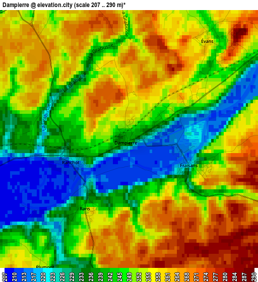
Below is the Elevation map of Dampierre, which displays elevation range with different colors. Scale of the first map is from 207 to 290 m (679 to 951 ft) with average elevation of 248.9 meters (=817 ft) [note 1]
These maps also provides idea of topography and contour of this city, they are displayed at different zoom levels. More info about maps, scale and edge coordinates you can find below images.
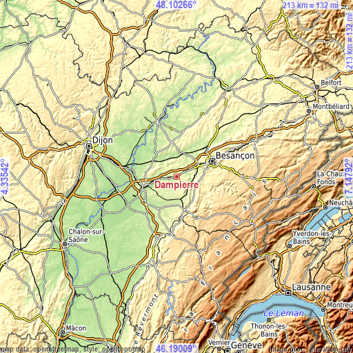
| \ | Map #1 | Topo.Map |
| Scale [m] | 207..290 m | × |
| Scale [ft] | 679..951 ft | × |
| Average | 248.9 m = 817 ft | × |
| Width | 6.65 km = 4.1 mi | 212.7 km = 132.2 mi |
| Height | 6.65 km = 4.1 mi | 212.6 km = 132.1 mi |
| ↑Max Latitude | 47.184855° | 48.10266° |
| Latitude at center | 47.15498° | 47.15498° |
| ↓Min Latitude | 47.125088° | 46.19009° |
| ← Min Longitude | 5.697725° | 4.33542° |
| Longitude center | 5.74167° | 5.74167° |
| →Max Longitude | 5.785615° | 7.14792° |
Nearby cities:
Cities around Dampierre sort by population:
• Saint-Vit elevation 248 m
6.5 km,  60°
60°
• Montferrand-le-Château 254 m
13.3 km,  80°
80°
• Franois 269 m
16.4 km, 59°
• Dannemarie-sur-Crête 259 m
11.2 km, 60°
• Grandfontaine 250 m
12.9 km,  68°
68°
• Arc-et-Senans 232 m
13.9 km,  171°
171°
• Marnay 205 m
15.3 km,  8°
8°
• Fraisans 225 m
1.6 km,  116°
116°
• Chemaudin 277 m
13.8 km, 56°
• Quingey 265 m
12.2 km, 118°
• Boussières 286 m
12.2 km,  88°
88°
• Orchamps 226 m
6.3 km,  262°
262°
Multilingual:
 En español:
Dampierre elevación 242 m.
 En France:
Dampierre élévation 242 m.
 Auf Deutsch:
Dampierre höhe über dem Meeresspiegel ist 242 m.

Sources and notes:
- [note 1] Map square and city borders are not equal. Map elevation data is calculated only from area inside that square.
- [src 1] Elevation data from geonames database provided with same terms of usage.
- [src 2] The elevation map of Dampierre is generated using elevation data from NASA's 3 arcsec (90m) resolution SRTM data.
- [src 3] Base (background) map © OpenStreetMap contributors tiles are generated by Geofabrik and OpenTopoMap.
Copyright & License:
This Dampierre Elevation Map is licensed under CC BY-SA. You may reuse any part from this page, if you give a proper credit by linking to this URL:
 More info on terms of use page.