Grandfontaine elevation
Grandfontaine (Bourgogne-Franche-Comté, Doubs), France elevation is 250 meters and Grandfontaine elevation in feet is 820 ft above sea level [src 1]. Grandfontaine is a populated place (feature code) with elevation that is 76 meters (249 ft) bigger than average city elevation in France.
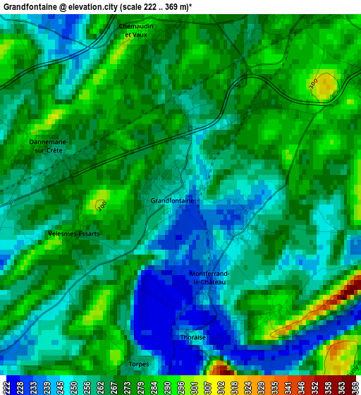
Below is the Elevation map of Grandfontaine, which displays elevation range with different colors. Scale of the first map is from 222 to 369 m (728 to 1211 ft) with average elevation of 265.3 meters (=870 ft) [note 1]
These maps also provides idea of topography and contour of this city, they are displayed at different zoom levels. More info about maps, scale and edge coordinates you can find below images.
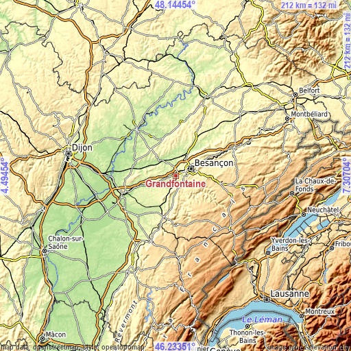
| \ | Map #1 | Topo.Map |
| Scale [m] | 222..369 m | × |
| Scale [ft] | 728..1211 ft | × |
| Average | 265.3 m = 870 ft | × |
| Width | 6.64 km = 4.1 mi | 212.5 km = 132 mi |
| Height | 6.64 km = 4.1 mi | 212.5 km = 132 mi |
| ↑Max Latitude | 47.227481° | 48.14454° |
| Latitude at center | 47.19763° | 47.19763° |
| ↓Min Latitude | 47.167762° | 46.23351° |
| ← Min Longitude | 5.856845° | 4.49454° |
| Longitude center | 5.90079° | 5.90079° |
| →Max Longitude | 5.944735° | 7.30704° |
Nearby cities:
Cities around Grandfontaine sort by population:
• Saint-Vit elevation 248 m
6.6 km,  255°
255°
• Avanne-Aveney 234 m
5 km,  86°
86°
• Montferrand-le-Château 254 m
2.7 km,  156°
156°
• Pouilley-les-Vignes 235 m
7.2 km,  21°
21°
• Franois 269 m
4.2 km,  29°
29°
• Serre-les-Sapins 280 m
6.3 km, 22°
• Pirey 299 m
8.6 km, 34°
• Dannemarie-sur-Crête 259 m
2.4 km,  289°
289°
• Beure 251 m
8 km,  82°
82°
• Chemaudin 277 m
3 km,  350°
350°
• Pelousey 230 m
8.8 km,  10°
10°
• Boussières 286 m
4.3 km,  177°
177°
Multilingual:
 En español:
Grandfontaine elevación 250 m.
 En France:
Grandfontaine élévation 250 m.
 Auf Deutsch:
Grandfontaine höhe über dem Meeresspiegel ist 250 m.

Sources and notes:
- [note 1] Map square and city borders are not equal. Map elevation data is calculated only from area inside that square.
- [src 1] Elevation data from geonames database provided with same terms of usage.
- [src 2] The elevation map of Grandfontaine is generated using elevation data from NASA's 3 arcsec (90m) resolution SRTM data.
- [src 3] Base (background) map © OpenStreetMap contributors tiles are generated by Geofabrik and OpenTopoMap.
Copyright & License:
This Grandfontaine Elevation Map is licensed under CC BY-SA. You may reuse any part from this page, if you give a proper credit by linking to this URL:
 More info on terms of use page.