Dieulefit elevation
Dieulefit (Auvergne-Rhône-Alpes, Département de la Drôme), France elevation is 428 meters and Dieulefit elevation in feet is 1404 ft above sea level [src 1]. Dieulefit is a populated place (feature code) with elevation that is 254 meters (833 ft) bigger than average city elevation in France.
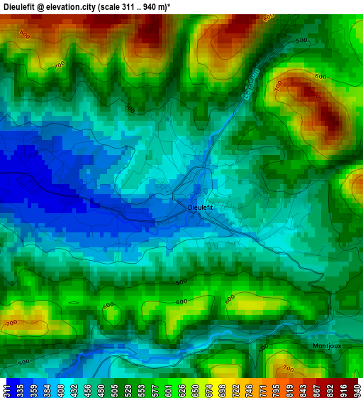
Below is the Elevation map of Dieulefit, which displays elevation range with different colors. Scale of the first map is from 311 to 940 m (1020 to 3084 ft) with average elevation of 522.5 meters (=1714 ft) [note 1]
These maps also provides idea of topography and contour of this city, they are displayed at different zoom levels. More info about maps, scale and edge coordinates you can find below images.
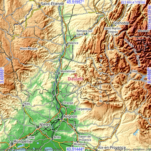
| \ | Map #1 | Topo.Map |
| Scale [m] | 311..940 m | × |
| Scale [ft] | 1020..3084 ft | × |
| Average | 522.5 m = 1714 ft | × |
| Width | 6.97 km = 4.3 mi | 222.9 km = 138.5 mi |
| Height | 6.97 km = 4.3 mi | 222.9 km = 138.5 mi |
| ↑Max Latitude | 44.556952° | 45.51957° |
| Latitude at center | 44.52563° | 44.52563° |
| ↓Min Latitude | 44.494291° | 43.51444° |
| ← Min Longitude | 5.017855° | 3.65555° |
| Longitude center | 5.0618° | 5.0618° |
| →Max Longitude | 5.105745° | 6.46805° |
Nearby cities:
Cities around Dieulefit sort by population:
• Valréas elevation 239 m
16.6 km,  199°
199°
• Nyons 300 m
19.4 km,  161°
161°
• Aouste-sur-Sye 229 m
21.4 km,  358°
358°
• Grillon 182 m
17.9 km,  215°
215°
• Sauzet 131 m
21 km,  294°
294°
• Taulignan 284 m
11.6 km, 218°
• Montboucher-sur-Jabron 125 m
20.8 km,  277°
277°
• Allan 192 m
21.7 km,  261°
261°
• Grignan 204 m
17 km,  226°
226°
• La Bégude-de-Mazenc 243 m
10.3 km, 280°
• Vinsobres 292 m
21.4 km,  179°
179°
• Marsanne 195 m
19.6 km,  311°
311°
Multilingual:
 En español:
Dieulefit elevación 428 m.
 En France:
Dieulefit élévation 428 m.
 Auf Deutsch:
Dieulefit höhe über dem Meeresspiegel ist 428 m.

Sources and notes:
- [note 1] Map square and city borders are not equal. Map elevation data is calculated only from area inside that square.
- [src 1] Elevation data from geonames database provided with same terms of usage.
- [src 2] The elevation map of Dieulefit is generated using elevation data from NASA's 3 arcsec (90m) resolution SRTM data.
- [src 3] Base (background) map © OpenStreetMap contributors tiles are generated by Geofabrik and OpenTopoMap.
Copyright & License:
This Dieulefit Elevation Map is licensed under CC BY-SA. You may reuse any part from this page, if you give a proper credit by linking to this URL:
 More info on terms of use page.