Vinsobres elevation
Vinsobres (Auvergne-Rhône-Alpes, Département de la Drôme), France elevation is 292 meters and Vinsobres elevation in feet is 958 ft above sea level [src 1]. Vinsobres is a populated place (feature code) with elevation that is 118 meters (387 ft) bigger than average city elevation in France.
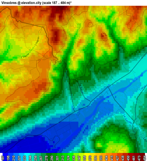
Below is the Elevation map of Vinsobres, which displays elevation range with different colors. Scale of the first map is from 187 to 484 m (614 to 1588 ft) with average elevation of 312.7 meters (=1026 ft) [note 1]
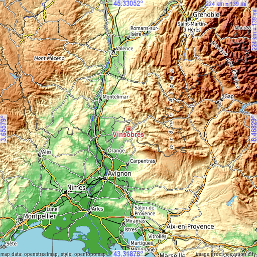
These maps also provides idea of topography and contour of this city, they are displayed at different zoom levels. More info about maps, scale and edge coordinates you can find below images.
| \ | Map #1 | Topo.Map |
| Scale [m] | 187..484 m | × |
| Scale [ft] | 614..1588 ft | × |
| Average | 312.7 m = 1026 ft | × |
| Width | 6.99 km = 4.3 mi | 223.7 km = 139 mi |
| Height | 6.99 km = 4.3 mi | 223.7 km = 139 mi |
| ↑Max Latitude | 44.364705° | 45.33052° |
| Latitude at center | 44.33328° | 44.33328° |
| ↓Min Latitude | 44.301838° | 43.31878° |
| ← Min Longitude | 5.018095° | 3.65579° |
| Longitude center | 5.06204° | 5.06204° |
| →Max Longitude | 5.105985° | 6.46829° |
Nearby cities:
Cities around Vinsobres sort by population:
• Valréas elevation 239 m
8 km,  315°
315°
• Nyons 300 m
7 km,  63°
63°
• Vaison-la-Romaine 212 m
10.5 km,  174°
174°
• Sainte-Cécile-les-Vignes 112 m
17.1 km,  235°
235°
• Grillon 182 m
12.6 km,  303°
303°
• Tulette 160 m
11.6 km, 243°
• Visan 200 m
9.1 km,  256°
256°
• Taulignan 284 m
14.3 km,  329°
329°
• Grignan 204 m
15.6 km,  308°
308°
• Mirabel-aux-Baronnies 261 m
4 km,  130°
130°
• Sablet 157 m
16.3 km,  196°
196°
• Montségur-sur-Lauzon 145 m
16.8 km,  280°
280°
Multilingual:
 En español:
Vinsobres elevación 292 m.
 En France:
Vinsobres élévation 292 m.
 Auf Deutsch:
Vinsobres höhe über dem Meeresspiegel ist 292 m.

Sources and notes:
- [note 1] Map square and city borders are not equal. Map elevation data is calculated only from area inside that square.
- [src 1] Elevation data from geonames database provided with same terms of usage.
- [src 2] The elevation map of Vinsobres is generated using elevation data from NASA's 3 arcsec (90m) resolution SRTM data.
- [src 3] Base (background) map © OpenStreetMap contributors tiles are generated by Geofabrik and OpenTopoMap.
Copyright & License:
This Vinsobres Elevation Map is licensed under CC BY-SA. You may reuse any part from this page, if you give a proper credit by linking to this URL:
 More info on terms of use page.