Digoin elevation
Digoin (Bourgogne-Franche-Comté, Département de Saône-et-Loire), France elevation is 236 meters and Digoin elevation in feet is 774 ft above sea level [src 1]. Digoin is a populated place (feature code) with elevation that is 62 meters (203 ft) bigger than average city elevation in France.
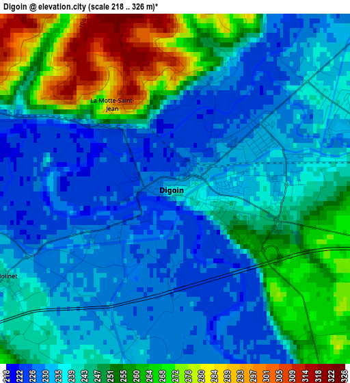
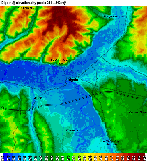
Below is the Elevation map of Digoin, which displays elevation range with different colors. Scale of the first map is from 218 to 326 m (715 to 1070 ft) with average elevation of 244 meters (=801 ft) [note 1]
These maps also provides idea of topography and contour of this city, they are displayed at different zoom levels. More info about maps, scale and edge coordinates you can find below images.
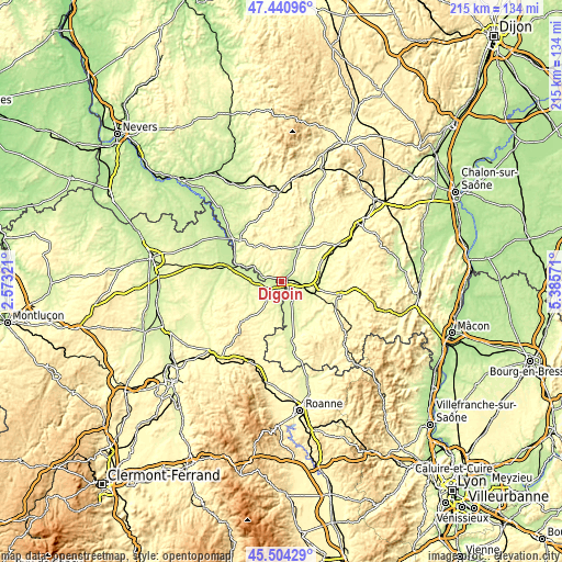
| \ | Map #1 | Map #2 | Topo.Map |
| Scale [m] | 218..326 m | 214..342 m | × |
| Scale [ft] | 715..1070 ft | 702..1122 ft | × |
| Average | 244 m = 801 ft | 259 m = 850 ft | × |
| Width | 6.73 km = 4.2 mi | 13.46 km = 8.4 mi | 215.3 km = 133.8 mi |
| Height | 6.73 km = 4.2 mi | 13.46 km = 8.4 mi | 215.3 km = 133.8 mi |
| ↑Max Latitude | 46.511492° | 46.541727° | 47.44096° |
| Latitude at center | 46.48124° | 46.48124° | 46.48124° |
| ↓Min Latitude | 46.450971° | 46.420686° | 45.50429° |
| ← Min Longitude | 3.935515° | 3.891569° | 2.57321° |
| Longitude center | 3.97946° | 3.97946° | 3.97946° |
| →Max Longitude | 4.023405° | 4.067351° | 5.38571° |
Nearby cities:
Cities around Digoin sort by population:
• Saint-François elevation 290 m
9.3 km,  217°
217°
• Paray-le-Monial 244 m
10.9 km,  105°
105°
• Gueugnon 243 m
15 km,  25°
25°
• Bourbon-Lancy 254 m
22.4 km,  314°
314°
• Charolles 287 m
23.2 km,  102°
102°
• Diou 214 m
18.9 km,  288°
288°
• Palinges 274 m
20.1 km,  66°
66°
• Génelard 272 m
22.6 km,  60°
60°
• La Motte-Saint-Jean 299 m
2 km,  324°
324°
• Le Donjon 302 m
20.4 km, 224°
• Molinet 240 m
3.8 km,  242°
242°
• Saint-Yan 245 m
9 km,  149°
149°
Multilingual:
 En español:
Digoin elevación 236 m.
 En France:
Digoin élévation 236 m.


Sources and notes:
- [note 1] Map square and city borders are not equal. Map elevation data is calculated only from area inside that square.
- [src 1] Elevation data from geonames database provided with same terms of usage.
- [src 2] The elevation map of Digoin is generated using elevation data from NASA's 3 arcsec (90m) resolution SRTM data.
- [src 3] Base (background) map © OpenStreetMap contributors tiles are generated by Geofabrik and OpenTopoMap.
Copyright & License:
This Digoin Elevation Map is licensed under CC BY-SA. You may reuse any part from this page, if you give a proper credit by linking to this URL:
 More info on terms of use page.