Doyet elevation
Doyet (Auvergne-Rhône-Alpes, Département de l'Allier), France elevation is 317 meters and Doyet elevation in feet is 1040 ft above sea level [src 1]. Doyet is a populated place (feature code) with elevation that is 143 meters (469 ft) bigger than average city elevation in France.
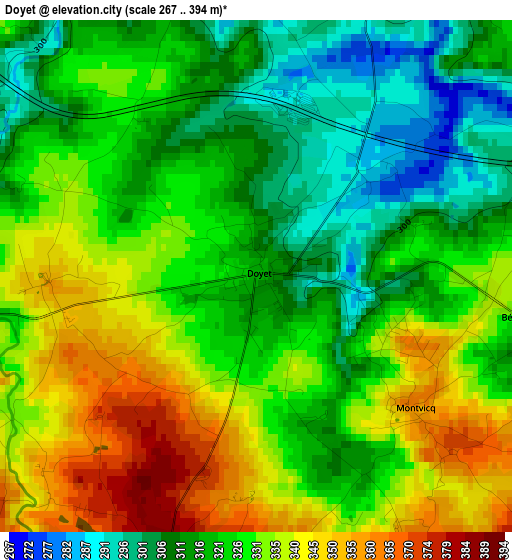
Below is the Elevation map of Doyet, which displays elevation range with different colors. Scale of the first map is from 267 to 394 m (876 to 1293 ft) with average elevation of 325.8 meters (=1069 ft) [note 1]
These maps also provides idea of topography and contour of this city, they are displayed at different zoom levels. More info about maps, scale and edge coordinates you can find below images.
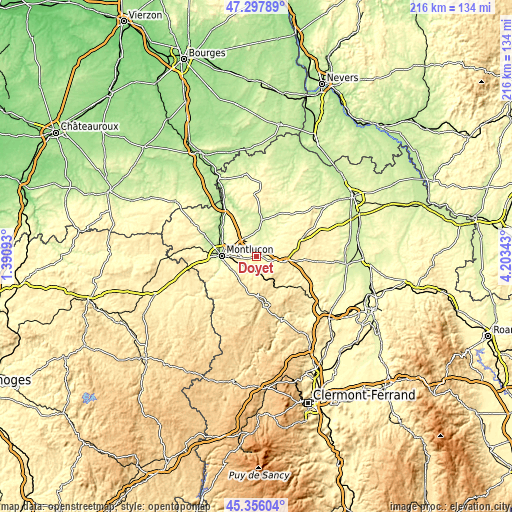
| \ | Map #1 | Topo.Map |
| Scale [m] | 267..394 m | × |
| Scale [ft] | 876..1293 ft | × |
| Average | 325.8 m = 1069 ft | × |
| Width | 6.75 km = 4.2 mi | 215.9 km = 134.2 mi |
| Height | 6.75 km = 4.2 mi | 215.9 km = 134.2 mi |
| ↑Max Latitude | 46.365913° | 47.29789° |
| Latitude at center | 46.33558° | 46.33558° |
| ↓Min Latitude | 46.30523° | 45.35604° |
| ← Min Longitude | 2.753235° | 1.39093° |
| Longitude center | 2.79718° | 2.79718° |
| →Max Longitude | 2.841125° | 4.20343° |
Nearby cities:
Cities around Doyet sort by population:
• Montluçon elevation 222 m
15 km,  271°
271°
• Commentry 381 m
6.7 km,  219°
219°
• Désertines 257 m
13.8 km,  278°
278°
• Néris-les-Bains 359 m
11.9 km,  243°
243°
• Saint-Victor 199 m
15.9 km,  294°
294°
• Montmarault 477 m
12.3 km,  99°
99°
• Villefranche-d’Allier 278 m
8.2 km,  34°
34°
• Larequille 497 m
11.9 km, 218°
• Lavault-Sainte-Anne 268 m
15.4 km,  259°
259°
• Estivareilles 208 m
16.9 km,  306°
306°
• Montaigut 625 m
17.4 km,  177°
177°
• Villebret 421 m
14.4 km, 237°
Multilingual:
 En español:
Doyet elevación 317 m.
 En France:
Doyet élévation 317 m.


Sources and notes:
- [note 1] Map square and city borders are not equal. Map elevation data is calculated only from area inside that square.
- [src 1] Elevation data from geonames database provided with same terms of usage.
- [src 2] The elevation map of Doyet is generated using elevation data from NASA's 3 arcsec (90m) resolution SRTM data.
- [src 3] Base (background) map © OpenStreetMap contributors tiles are generated by Geofabrik and OpenTopoMap.
Copyright & License:
This Doyet Elevation Map is licensed under CC BY-SA. You may reuse any part from this page, if you give a proper credit by linking to this URL:
 More info on terms of use page.