Gaillard elevation
Gaillard (Auvergne-Rhône-Alpes, Haute-Savoie), France elevation is 421 meters and Gaillard elevation in feet is 1381 ft above sea level [src 1]. Gaillard is a populated place (feature code) with elevation that is 247 meters (810 ft) bigger than average city elevation in France.
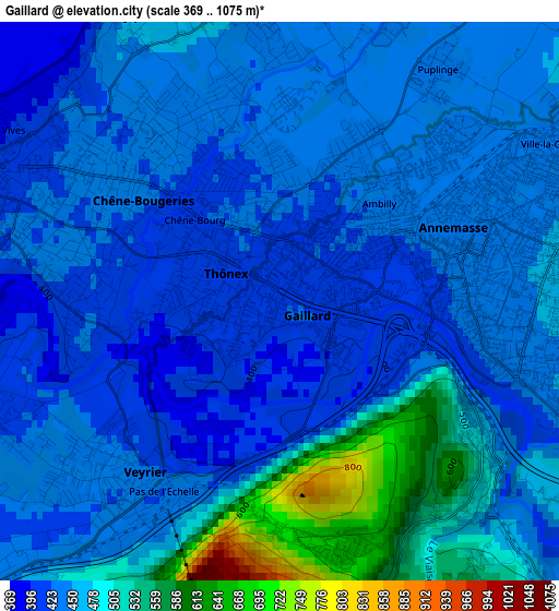
Below is the Elevation map of Gaillard, which displays elevation range with different colors. Scale of the first map is from 369 to 1075 m (1211 to 3527 ft) with average elevation of 457.2 meters (=1500 ft) [note 1]
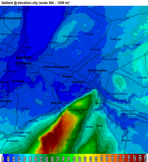
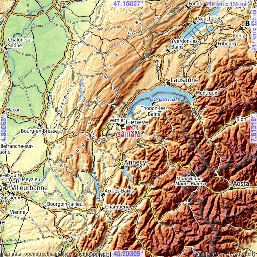
These maps also provides idea of topography and contour of this city, they are displayed at different zoom levels. More info about maps, scale and edge coordinates you can find below images.
| \ | Map #1 | Map #2 | Topo.Map |
| Scale [m] | 369..1075 m | 364..1299 m | × |
| Scale [ft] | 1211..3527 ft | 1194..4262 ft | × |
| Average | 457.2 m = 1500 ft | 497.4 m = 1632 ft | × |
| Width | 6.77 km = 4.2 mi | 13.53 km = 8.4 mi | 216.5 km = 134.5 mi |
| Height | 6.77 km = 4.2 mi | 13.53 km = 8.4 mi | 216.5 km = 134.5 mi |
| ↑Max Latitude | 46.215716° | 46.246115° | 47.15027° |
| Latitude at center | 46.1853° | 46.1853° | 46.1853° |
| ↓Min Latitude | 46.154867° | 46.124417° | 45.20309° |
| ← Min Longitude | 6.162985° | 6.119039° | 4.80068° |
| Longitude center | 6.20693° | 6.20693° | 6.20693° |
| →Max Longitude | 6.250875° | 6.294821° | 7.61318° |
Nearby cities:
Cities around Gaillard sort by population:
• Annemasse elevation 441 m
2.6 km,  66°
66°
• Ville-la-Grand 443 m
3.9 km,  59°
59°
• Vétraz-Monthoux 495 m
4.2 km,  107°
107°
• Reignier-Ésery 484 m
7.4 km,  141°
141°
• Cranves-Sales 559 m
7.1 km,  87°
87°
• Collonges-sous-Salève 555 m
6.4 km,  220°
220°
• Bonne 546 m
9.2 km,  99°
99°
• Monnetier-Mornex 702 m
2.8 km,  180°
180°
• Étrembières 427 m
1.7 km, 113°
• Archamps 588 m
8.6 km,  226°
226°
• Lucinges 796 m
8.4 km, 85°
• Arthaz-Pont-Notre-Dame 478 m
5.4 km,  122°
122°
Multilingual:
 En español:
Gaillard elevación 421 m.
 En France:
Gaillard élévation 421 m.
 Auf Deutsch:
Gaillard höhe über dem Meeresspiegel ist 421 m.

Sources and notes:
- [note 1] Map square and city borders are not equal. Map elevation data is calculated only from area inside that square.
- [src 1] Elevation data from geonames database provided with same terms of usage.
- [src 2] The elevation map of Gaillard is generated using elevation data from NASA's 3 arcsec (90m) resolution SRTM data.
- [src 3] Base (background) map © OpenStreetMap contributors tiles are generated by Geofabrik and OpenTopoMap.
Copyright & License:
This Gaillard Elevation Map is licensed under CC BY-SA. You may reuse any part from this page, if you give a proper credit by linking to this URL:
 More info on terms of use page.