Bonne elevation
Bonne (Auvergne-Rhône-Alpes, Haute-Savoie), France elevation is 546 meters and Bonne elevation in feet is 1791 ft above sea level [src 1]. Bonne is a populated place (feature code) with elevation that is 372 meters (1220 ft) bigger than average city elevation in France.
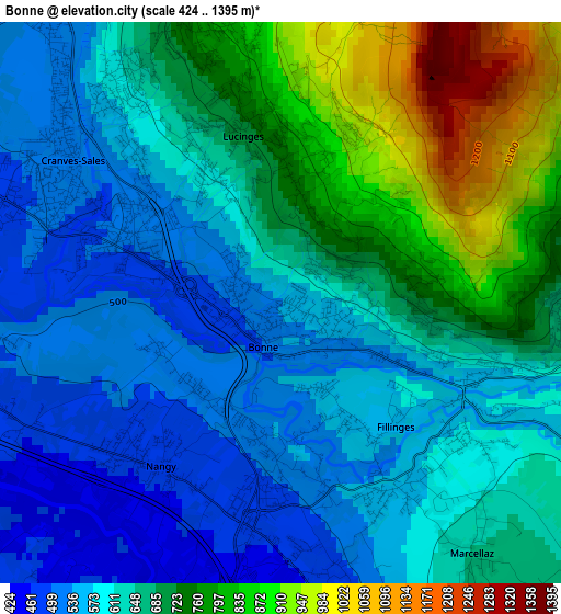
Below is the Elevation map of Bonne, which displays elevation range with different colors. Scale of the first map is from 424 to 1395 m (1391 to 4577 ft) with average elevation of 653.1 meters (=2143 ft) [note 1]
These maps also provides idea of topography and contour of this city, they are displayed at different zoom levels. More info about maps, scale and edge coordinates you can find below images.
| \ | Map #1 | Topo.Map |
| Scale [m] | 424..1395 m | × |
| Scale [ft] | 1391..4577 ft | × |
| Average | 653.1 m = 2143 ft | × |
| Width | 6.77 km = 4.2 mi | 216.6 km = 134.6 mi |
| Height | 6.77 km = 4.2 mi | 216.5 km = 134.5 mi |
| ↑Max Latitude | 46.202493° | 47.13727° |
| Latitude at center | 46.17207° | 46.17207° |
| ↓Min Latitude | 46.14163° | 45.18962° |
| ← Min Longitude | 6.280485° | 4.91818° |
| Longitude center | 6.32443° | 6.32443° |
| →Max Longitude | 6.368375° | 7.73068° |
Nearby cities:
Cities around Bonne sort by population:
• Annemasse elevation 441 m
7.1 km,  290°
290°
• Ville-la-Grand 443 m
6.7 km,  301°
301°
• Vétraz-Monthoux 495 m
5.1 km,  272°
272°
• Reignier-Ésery 484 m
6.2 km,  225°
225°
• Cranves-Sales 559 m
2.6 km,  312°
312°
• Viuz-en-Sallaz 632 m
7 km,  113°
113°
• Saint-Cergues 687 m
6.5 km,  356°
356°
• Fillinges 573 m
2 km,  135°
135°
• Contamine-sur-Arve 526 m
3.4 km,  169°
169°
• Lucinges 796 m
2.3 km,  341°
341°
• Arthaz-Pont-Notre-Dame 478 m
4.7 km,  252°
252°
• Peillonnex 640 m
6.3 km, 139°
Multilingual:
 En español:
Bonne elevación 546 m.
 En France:
Bonne élévation 546 m.


Sources and notes:
- [note 1] Map square and city borders are not equal. Map elevation data is calculated only from area inside that square.
- [src 1] Elevation data from geonames database provided with same terms of usage.
- [src 2] The elevation map of Bonne is generated using elevation data from NASA's 3 arcsec (90m) resolution SRTM data.
- [src 3] Base (background) map © OpenStreetMap contributors tiles are generated by Geofabrik and OpenTopoMap.
Copyright & License:
This Bonne Elevation Map is licensed under CC BY-SA. You may reuse any part from this page, if you give a proper credit by linking to this URL:
 More info on terms of use page.