Garancières elevation
Garancières (Île-de-France, Yvelines), France elevation is 103 meters and Garancières elevation in feet is 338 ft above sea level [src 1]. Garancières is a populated place (feature code) with elevation that is 71 meters (233 ft) smaller than average city elevation in France.
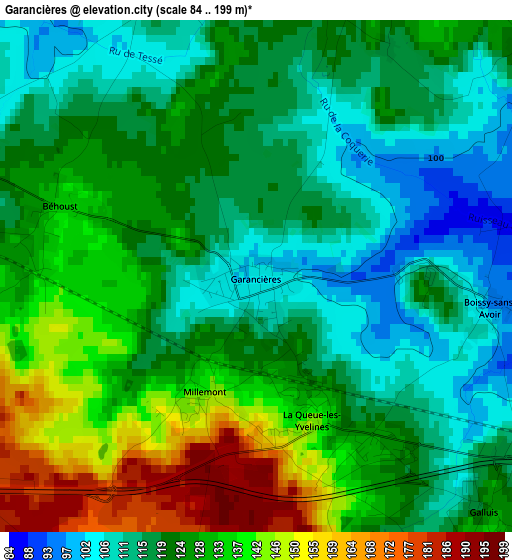
Below is the Elevation map of Garancières, which displays elevation range with different colors. Scale of the first map is from 84 to 199 m (276 to 653 ft) with average elevation of 124.7 meters (=409 ft) [note 1]
These maps also provides idea of topography and contour of this city, they are displayed at different zoom levels. More info about maps, scale and edge coordinates you can find below images.
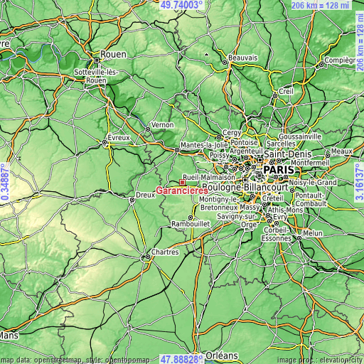
| \ | Map #1 | Topo.Map |
| Scale [m] | 84..199 m | × |
| Scale [ft] | 276..653 ft | × |
| Average | 124.7 m = 409 ft | × |
| Width | 6.43 km = 4 mi | 205.9 km = 127.9 mi |
| Height | 6.43 km = 4 mi | 205.9 km = 127.9 mi |
| ↑Max Latitude | 48.851635° | 49.74003° |
| Latitude at center | 48.82271° | 48.82271° |
| ↓Min Latitude | 48.793768° | 47.88828° |
| ← Min Longitude | 1.711175° | 0.34887° |
| Longitude center | 1.75512° | 1.75512° |
| →Max Longitude | 1.799065° | 3.16137° |
Nearby cities:
Cities around Garancières sort by population:
• Beynes elevation 54 m
9.4 km,  66°
66°
• Villiers-Saint-Fréderic 102 m
9.4 km,  94°
94°
• Orgerus 123 m
4.3 km,  294°
294°
• Septeuil 97 m
9.4 km,  325°
325°
• Gambais 120 m
8.2 km,  228°
228°
• La Queue-les-Yvelines 146 m
2.7 km,  161°
161°
• Saint-Germain-de-la-Grange 110 m
10.6 km,  82°
82°
• Méré 141 m
6 km,  135°
135°
• Bazainville 129 m
6.7 km,  252°
252°
• Galluis 126 m
4.1 km, 135°
• Thoiry 145 m
5.8 km,  32°
32°
• Tacoignières 145 m
6.1 km,  284°
284°
Multilingual:
 En español:
Garancières elevación 103 m.
 En France:
Garancières élévation 103 m.
 Auf Deutsch:
Garancières höhe über dem Meeresspiegel ist 103 m.

Sources and notes:
- [note 1] Map square and city borders are not equal. Map elevation data is calculated only from area inside that square.
- [src 1] Elevation data from geonames database provided with same terms of usage.
- [src 2] The elevation map of Garancières is generated using elevation data from NASA's 3 arcsec (90m) resolution SRTM data.
- [src 3] Base (background) map © OpenStreetMap contributors tiles are generated by Geofabrik and OpenTopoMap.
Copyright & License:
This Garancières Elevation Map is licensed under CC BY-SA. You may reuse any part from this page, if you give a proper credit by linking to this URL:
 More info on terms of use page.