Gex elevation
Gex (Auvergne-Rhône-Alpes, Département de l'Ain), France elevation is 575 meters and Gex elevation in feet is 1886 ft above sea level [src 1]. Gex is a seat of a third-order administrative division (feature code) with elevation that is 401 meters (1316 ft) bigger than average city elevation in France.
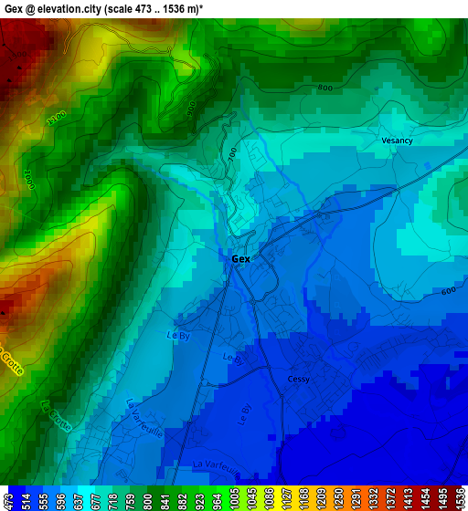
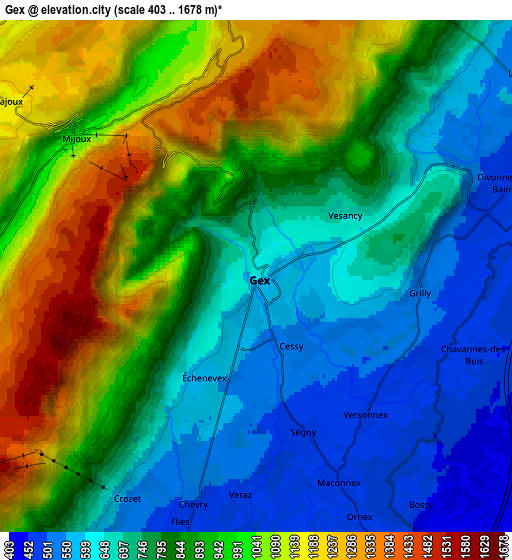
Below is the Elevation map of Gex, which displays elevation range with different colors. Scale of the first map is from 473 to 1536 m (1552 to 5039 ft) with average elevation of 742.1 meters (=2435 ft) [note 1]
These maps also provides idea of topography and contour of this city, they are displayed at different zoom levels. More info about maps, scale and edge coordinates you can find below images.
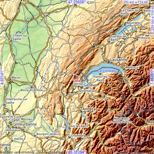
| \ | Map #1 | Map #2 | Topo.Map |
| Scale [m] | 473..1536 m | 403..1678 m | × |
| Scale [ft] | 1552..5039 ft | 1322..5505 ft | × |
| Average | 742.1 m = 2435 ft | 850.2 m = 2789 ft | × |
| Width | 6.75 km = 4.2 mi | 13.5 km = 8.4 mi | 215.9 km = 134.2 mi |
| Height | 6.75 km = 4.2 mi | 13.5 km = 8.4 mi | 215.9 km = 134.2 mi |
| ↑Max Latitude | 46.363564° | 46.393882° | 47.29558° |
| Latitude at center | 46.33323° | 46.33323° | 46.33323° |
| ↓Min Latitude | 46.302879° | 46.272511° | 45.35364° |
| ← Min Longitude | 6.013715° | 5.969769° | 4.65141° |
| Longitude center | 6.05766° | 6.05766° | 6.05766° |
| →Max Longitude | 6.101605° | 6.145551° | 7.46391° |
Nearby cities:
Cities around Gex sort by population:
• Ferney-Voltaire elevation 425 m
9.2 km,  153°
153°
• Saint-Genis-Pouilly 453 m
10.4 km,  195°
195°
• Divonne-les-Bains 470 m
6.5 km,  65°
65°
• Thoiry 489 m
12.1 km,  208°
208°
• Ornex 476 m
7.5 km, 154°
• Cessy 533 m
1.9 km,  137°
137°
• Ségny 481 m
4.3 km,  164°
164°
• Sergy 458 m
10.1 km, 205°
• Échenevex 580 m
3 km, 207°
• Saint-Jean-de-Gonville 522 m
15.7 km, 211°
• Chevry 474 m
5.9 km,  194°
194°
• Sauverny 477 m
5.1 km,  113°
113°
Multilingual:
 En español:
Gex elevación 575 m.
 En France:
Gex élévation 575 m.


Sources and notes:
- [note 1] Map square and city borders are not equal. Map elevation data is calculated only from area inside that square.
- [src 1] Elevation data from geonames database provided with same terms of usage.
- [src 2] The elevation map of Gex is generated using elevation data from NASA's 3 arcsec (90m) resolution SRTM data.
- [src 3] Base (background) map © OpenStreetMap contributors tiles are generated by Geofabrik and OpenTopoMap.
Copyright & License:
This Gex Elevation Map is licensed under CC BY-SA. You may reuse any part from this page, if you give a proper credit by linking to this URL:
 More info on terms of use page.