Saint-Genis-Pouilly elevation
Saint-Genis-Pouilly (Auvergne-Rhône-Alpes, Département de l'Ain), France elevation is 453 meters and Saint-Genis-Pouilly elevation in feet is 1486 ft above sea level [src 1]. Saint-Genis-Pouilly is a populated place (feature code) with elevation that is 279 meters (915 ft) bigger than average city elevation in France.
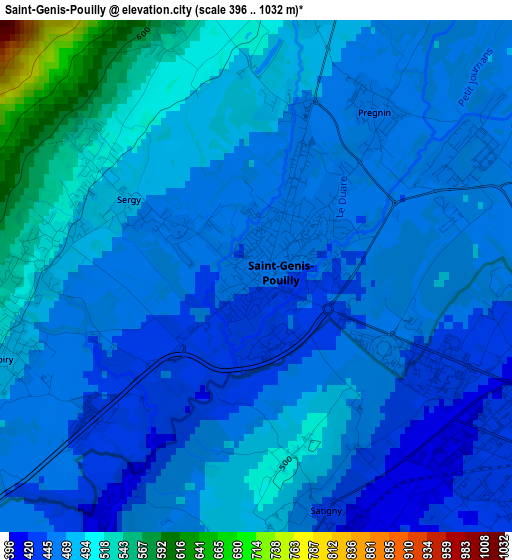
Below is the Elevation map of Saint-Genis-Pouilly, which displays elevation range with different colors. Scale of the first map is from 396 to 1032 m (1299 to 3386 ft) with average elevation of 472.5 meters (=1550 ft) [note 1]
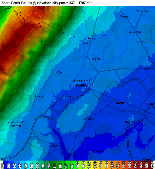
These maps also provides idea of topography and contour of this city, they are displayed at different zoom levels. More info about maps, scale and edge coordinates you can find below images.
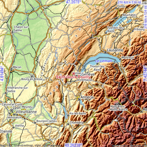
| \ | Map #1 | Map #2 | Topo.Map |
| Scale [m] | 396..1032 m | 337..1707 m | × |
| Scale [ft] | 1299..3386 ft | 1106..5600 ft | × |
| Average | 472.5 m = 1550 ft | 603.3 m = 1979 ft | × |
| Width | 6.76 km = 4.2 mi | 13.52 km = 8.4 mi | 216.3 km = 134.4 mi |
| Height | 6.76 km = 4.2 mi | 13.52 km = 8.4 mi | 216.3 km = 134.4 mi |
| ↑Max Latitude | 46.273944° | 46.304311° | 47.2075° |
| Latitude at center | 46.24356° | 46.24356° | 46.24356° |
| ↓Min Latitude | 46.213159° | 46.182742° | 45.26238° |
| ← Min Longitude | 5.977245° | 5.933299° | 4.61494° |
| Longitude center | 6.02119° | 6.02119° | 6.02119° |
| →Max Longitude | 6.065135° | 6.109081° | 7.42744° |
Nearby cities:
Cities around Saint-Genis-Pouilly sort by population:
• Gex elevation 575 m
10.4 km,  15°
15°
• Ferney-Voltaire 425 m
7.1 km,  76°
76°
• Thoiry 489 m
3.2 km,  257°
257°
• Ornex 476 m
6.9 km,  61°
61°
• Cessy 533 m
9.5 km,  25°
25°
• Péron 542 m
9.4 km,  231°
231°
• Ségny 481 m
7 km, 34°
• Sergy 458 m
1.7 km,  298°
298°
• Échenevex 580 m
7.4 km,  10°
10°
• Saint-Jean-de-Gonville 522 m
6.4 km,  237°
237°
• Challex 508 m
7.4 km,  207°
207°
• Chevry 474 m
4.4 km, 17°
Multilingual:
 En español:
Saint-Genis-Pouilly elevación 453 m.
 En France:
Saint-Genis-Pouilly élévation 453 m.
 Auf Deutsch:
Saint-Genis-Pouilly höhe über dem Meeresspiegel ist 453 m.

Sources and notes:
- [note 1] Map square and city borders are not equal. Map elevation data is calculated only from area inside that square.
- [src 1] Elevation data from geonames database provided with same terms of usage.
- [src 2] The elevation map of Saint-Genis-Pouilly is generated using elevation data from NASA's 3 arcsec (90m) resolution SRTM data.
- [src 3] Base (background) map © OpenStreetMap contributors tiles are generated by Geofabrik and OpenTopoMap.
Copyright & License:
This Saint-Genis-Pouilly Elevation Map is licensed under CC BY-SA. You may reuse any part from this page, if you give a proper credit by linking to this URL:
 More info on terms of use page.