Hauterives elevation
Hauterives (Auvergne-Rhône-Alpes, Département de la Drôme), France elevation is 300 meters and Hauterives elevation in feet is 984 ft above sea level [src 1]. Hauterives is a populated place (feature code) with elevation that is 126 meters (413 ft) bigger than average city elevation in France.
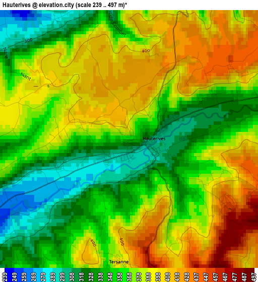
Below is the Elevation map of Hauterives, which displays elevation range with different colors. Scale of the first map is from 239 to 497 m (784 to 1631 ft) with average elevation of 371.4 meters (=1219 ft) [note 1]
These maps also provides idea of topography and contour of this city, they are displayed at different zoom levels. More info about maps, scale and edge coordinates you can find below images.
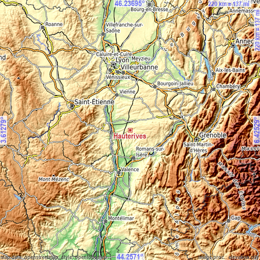
| \ | Map #1 | Topo.Map |
| Scale [m] | 239..497 m | × |
| Scale [ft] | 784..1631 ft | × |
| Average | 371.4 m = 1219 ft | × |
| Width | 6.88 km = 4.3 mi | 220.1 km = 136.8 mi |
| Height | 6.88 km = 4.3 mi | 220.1 km = 136.8 mi |
| ↑Max Latitude | 45.286577° | 46.23695° |
| Latitude at center | 45.25565° | 45.25565° |
| ↓Min Latitude | 45.224707° | 44.2571° |
| ← Min Longitude | 4.975095° | 3.61279° |
| Longitude center | 5.01904° | 5.01904° |
| →Max Longitude | 5.062985° | 6.42529° |
Nearby cities:
Cities around Hauterives sort by population:
• Beaurepaire elevation 257 m
9.3 km,  14°
14°
• Anneyron 208 m
10.6 km,  280°
280°
• Chanas 181 m
17.2 km,  294°
294°
• Châteauneuf-de-Galaure 253 m
5.6 km,  239°
239°
• Saint-Barthélemy-de-Vals 176 m
15 km,  230°
230°
• Saint-Uze 211 m
14.8 km, 237°
• Saint-Sorlin-en-Valloire 241 m
6.5 km,  303°
303°
• Viriville 392 m
15.9 km,  65°
65°
• Beausemblant 159 m
15.2 km,  253°
253°
• Andancette 147 m
16.5 km,  267°
267°
• Épinouze 228 m
9.3 km,  310°
310°
• Sonnay 250 m
14.5 km,  321°
321°
Multilingual:
 En español:
Hauterives elevación 300 m.
 En France:
Hauterives élévation 300 m.
 Auf Deutsch:
Hauterives höhe über dem Meeresspiegel ist 300 m.

Sources and notes:
- [note 1] Map square and city borders are not equal. Map elevation data is calculated only from area inside that square.
- [src 1] Elevation data from geonames database provided with same terms of usage.
- [src 2] The elevation map of Hauterives is generated using elevation data from NASA's 3 arcsec (90m) resolution SRTM data.
- [src 3] Base (background) map © OpenStreetMap contributors tiles are generated by Geofabrik and OpenTopoMap.
Copyright & License:
This Hauterives Elevation Map is licensed under CC BY-SA. You may reuse any part from this page, if you give a proper credit by linking to this URL:
 More info on terms of use page.