Huningue elevation
Huningue (Grand Est, Haut-Rhin), France elevation is 242 meters and Huningue elevation in feet is 794 ft above sea level [src 1]. Huningue is a populated place (feature code) with elevation that is 68 meters (223 ft) bigger than average city elevation in France.
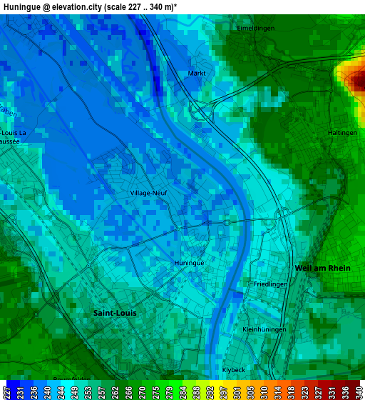
Below is the Elevation map of Huningue, which displays elevation range with different colors. Scale of the first map is from 227 to 340 m (745 to 1115 ft) with average elevation of 251.5 meters (=825 ft) [note 1]
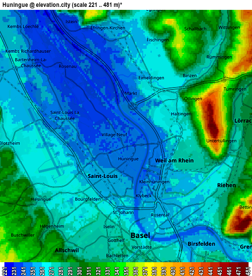
These maps also provides idea of topography and contour of this city, they are displayed at different zoom levels. More info about maps, scale and edge coordinates you can find below images.
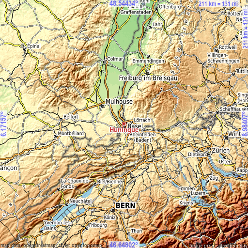
| \ | Map #1 | Map #2 | Topo.Map |
| Scale [m] | 227..340 m | 221..481 m | × |
| Scale [ft] | 745..1115 ft | 725..1578 ft | × |
| Average | 251.5 m = 825 ft | 277.6 m = 911 ft | × |
| Width | 6.59 km = 4.1 mi | 13.18 km = 8.2 mi | 210.9 km = 131 mi |
| Height | 6.59 km = 4.1 mi | 13.18 km = 8.2 mi | 210.8 km = 131 mi |
| ↑Max Latitude | 47.634391° | 47.663996° | 48.54434° |
| Latitude at center | 47.60477° | 47.60477° | 47.60477° |
| ↓Min Latitude | 47.575132° | 47.545477° | 46.64802° |
| ← Min Longitude | 7.533875° | 7.489929° | 6.17157° |
| Longitude center | 7.57782° | 7.57782° | 7.57782° |
| →Max Longitude | 7.621765° | 7.665711° | 8.98407° |
Nearby cities:
Cities around Huningue sort by population:
• Saint-Louis elevation 245 m
2 km,  224°
224°
• Kembs 240 m
11 km,  329°
329°
• Blotzheim 268 m
6.1 km,  267°
267°
• Village-Neuf 239 m
0.7 km,  290°
290°
• Bartenheim 259 m
8 km, 293°
• Hégenheim 279 m
6.2 km, 220°
• Sierentz 254 m
11 km,  302°
302°
• Hésingue 271 m
5.3 km,  236°
236°
• Rosenau 239 m
4.8 km,  318°
318°
• Dietwiller 250 m
16.3 km,  306°
306°
• Leymen 353 m
13.9 km,  209°
209°
• Hagenthal-le-Bas 360 m
11.6 km, 220°
Multilingual:
 En español:
Huningue elevación 242 m.
 En France:
Huningue élévation 242 m.
 Auf Deutsch:
Huningue höhe über dem Meeresspiegel ist 242 m.

Sources and notes:
- [note 1] Map square and city borders are not equal. Map elevation data is calculated only from area inside that square.
- [src 1] Elevation data from geonames database provided with same terms of usage.
- [src 2] The elevation map of Huningue is generated using elevation data from NASA's 3 arcsec (90m) resolution SRTM data.
- [src 3] Base (background) map © OpenStreetMap contributors tiles are generated by Geofabrik and OpenTopoMap.
Copyright & License:
This Huningue Elevation Map is licensed under CC BY-SA. You may reuse any part from this page, if you give a proper credit by linking to this URL:
 More info on terms of use page.