Ingwiller elevation
Ingwiller (Grand Est, Bas-Rhin), France elevation is 191 meters and Ingwiller elevation in feet is 627 ft above sea level [src 1]. Ingwiller is a populated place (feature code) with elevation that is 17 meters (56 ft) bigger than average city elevation in France.
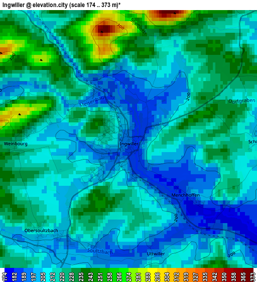
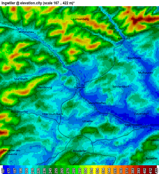
Below is the Elevation map of Ingwiller, which displays elevation range with different colors. Scale of the first map is from 174 to 373 m (571 to 1224 ft) with average elevation of 216.7 meters (=711 ft) [note 1]
These maps also provides idea of topography and contour of this city, they are displayed at different zoom levels. More info about maps, scale and edge coordinates you can find below images.
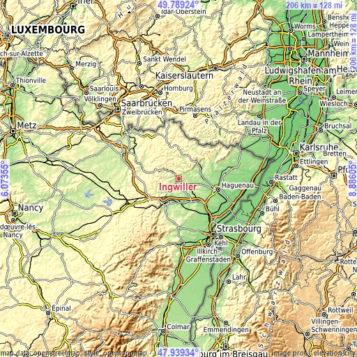
| \ | Map #1 | Map #2 | Topo.Map |
| Scale [m] | 174..373 m | 167..422 m | × |
| Scale [ft] | 571..1224 ft | 548..1385 ft | × |
| Average | 216.7 m = 711 ft | 235.9 m = 774 ft | × |
| Width | 6.43 km = 4 mi | 12.86 km = 8 mi | 205.7 km = 127.8 mi |
| Height | 6.43 km = 4 mi | 12.86 km = 8 mi | 205.7 km = 127.8 mi |
| ↑Max Latitude | 48.901736° | 48.930615° | 49.78924° |
| Latitude at center | 48.87284° | 48.87284° | 48.87284° |
| ↓Min Latitude | 48.843927° | 48.814998° | 47.93934° |
| ← Min Longitude | 7.435855° | 7.391909° | 6.07355° |
| Longitude center | 7.4798° | 7.4798° | 7.4798° |
| →Max Longitude | 7.523745° | 7.567691° | 8.88605° |
Nearby cities:
Cities around Ingwiller sort by population:
• Bouxwiller elevation 226 m
5.3 km,  178°
178°
• Dettwiller 176 m
13.2 km, 184°
• Pfaffenhoffen 171 m
9.9 km,  110°
110°
• Steinbourg 193 m
12.4 km,  203°
203°
• Wingen-sur-Moder 217 m
8.9 km,  305°
305°
• Obermodern-Zutzendorf 173 m
4.7 km,  122°
122°
• Oberbronn 272 m
11.9 km,  51°
51°
• Gumbrechtshoffen 174 m
11.5 km,  71°
71°
• Uberach 164 m
11.2 km,  103°
103°
• Dossenheim-sur-Zinsel 192 m
9.3 km,  217°
217°
• Neuwiller-lès-Saverne 218 m
7.6 km,  225°
225°
• Wimmenau 210 m
6.1 km,  315°
315°
Multilingual:
 En español:
Ingwiller elevación 191 m.
 En France:
Ingwiller élévation 191 m.
 Auf Deutsch:
Ingweiler höhe über dem Meeresspiegel ist 191 m.

Sources and notes:
- [note 1] Map square and city borders are not equal. Map elevation data is calculated only from area inside that square.
- [src 1] Elevation data from geonames database provided with same terms of usage.
- [src 2] The elevation map of Ingwiller is generated using elevation data from NASA's 3 arcsec (90m) resolution SRTM data.
- [src 3] Base (background) map © OpenStreetMap contributors tiles are generated by Geofabrik and OpenTopoMap.
Copyright & License:
This Ingwiller Elevation Map is licensed under CC BY-SA. You may reuse any part from this page, if you give a proper credit by linking to this URL:
 More info on terms of use page.