Wingen-sur-Moder elevation
Wingen-sur-Moder (Grand Est, Bas-Rhin), France elevation is 217 meters and Wingen-sur-Moder elevation in feet is 712 ft above sea level [src 1]. Wingen-sur-Moder is a populated place (feature code) with elevation that is 43 meters (141 ft) bigger than average city elevation in France.
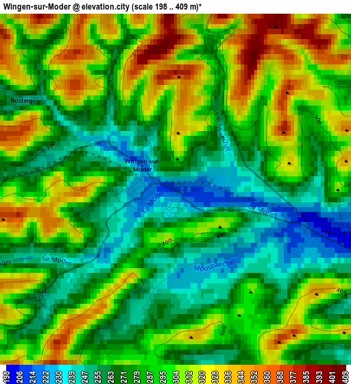
Below is the Elevation map of Wingen-sur-Moder, which displays elevation range with different colors. Scale of the first map is from 198 to 409 m (650 to 1342 ft) with average elevation of 288.3 meters (=946 ft) [note 1]
These maps also provides idea of topography and contour of this city, they are displayed at different zoom levels. More info about maps, scale and edge coordinates you can find below images.
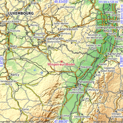
| \ | Map #1 | Topo.Map |
| Scale [m] | 198..409 m | × |
| Scale [ft] | 650..1342 ft | × |
| Average | 288.3 m = 946 ft | × |
| Width | 6.42 km = 4 mi | 205.5 km = 127.7 mi |
| Height | 6.42 km = 4 mi | 205.5 km = 127.7 mi |
| ↑Max Latitude | 48.947869° | 49.83455° |
| Latitude at center | 48.919° | 48.919° |
| ↓Min Latitude | 48.890114° | 47.98636° |
| ← Min Longitude | 7.335605° | 5.9733° |
| Longitude center | 7.37955° | 7.37955° |
| →Max Longitude | 7.423495° | 8.7858° |
Nearby cities:
Cities around Wingen-sur-Moder sort by population:
• Ingwiller elevation 191 m
8.9 km,  125°
125°
• Bouxwiller 226 m
12.8 km,  144°
144°
• Goetzenbruck 368 m
6.5 km,  0°
0°
• Diemeringen 261 m
14.2 km,  279°
279°
• Montbronn 348 m
9.6 km,  328°
328°
• Obermodern-Zutzendorf 173 m
13.6 km,  124°
124°
• Lemberg 359 m
9.2 km,  359°
359°
• Enchenberg 377 m
10.9 km,  344°
344°
• Soucht 280 m
5.5 km,  323°
323°
• Dossenheim-sur-Zinsel 192 m
12.7 km,  172°
172°
• Neuwiller-lès-Saverne 218 m
10.6 km, 169°
• Wimmenau 210 m
3.2 km,  103°
103°
Multilingual:
 En español:
Wingen-sur-Moder elevación 217 m.
 En France:
Wingen-sur-Moder élévation 217 m.
 Auf Deutsch:
Wingen-sur-Moder höhe über dem Meeresspiegel ist 217 m.

Sources and notes:
- [note 1] Map square and city borders are not equal. Map elevation data is calculated only from area inside that square.
- [src 1] Elevation data from geonames database provided with same terms of usage.
- [src 2] The elevation map of Wingen-sur-Moder is generated using elevation data from NASA's 3 arcsec (90m) resolution SRTM data.
- [src 3] Base (background) map © OpenStreetMap contributors tiles are generated by Geofabrik and OpenTopoMap.
Copyright & License:
This Wingen-sur-Moder Elevation Map is licensed under CC BY-SA. You may reuse any part from this page, if you give a proper credit by linking to this URL:
 More info on terms of use page.