Janzé elevation
Janzé (Brittany, Département d'Ille-et-Vilaine), France elevation is 86 meters and Janzé elevation in feet is 282 ft above sea level [src 1]. Janzé is a populated place (feature code) with elevation that is 88 meters (289 ft) smaller than average city elevation in France.
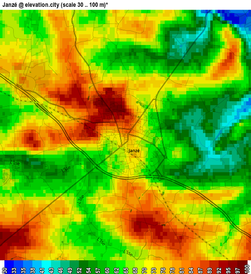
Below is the Elevation map of Janzé, which displays elevation range with different colors. Scale of the first map is from 30 to 100 m (98 to 328 ft) with average elevation of 68.8 meters (=226 ft) [note 1]
These maps also provides idea of topography and contour of this city, they are displayed at different zoom levels. More info about maps, scale and edge coordinates you can find below images.
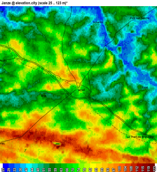
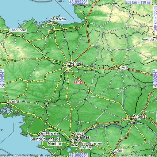
| \ | Map #1 | Map #2 | Topo.Map |
| Scale [m] | 30..100 m | 25..123 m | × |
| Scale [ft] | 98..328 ft | 82..404 ft | × |
| Average | 68.8 m = 226 ft | 68 m = 223 ft | × |
| Width | 6.54 km = 4.1 mi | 13.09 km = 8.1 mi | 209.4 km = 130.1 mi |
| Height | 6.54 km = 4.1 mi | 13.09 km = 8.1 mi | 209.4 km = 130.1 mi |
| ↑Max Latitude | 47.98857° | 48.017973° | 48.89229° |
| Latitude at center | 47.95915° | 47.95915° | 47.95915° |
| ↓Min Latitude | 47.929713° | 47.90026° | 47.00885° |
| ← Min Longitude | -1.542235° | -1.586181° | -2.90454° |
| Longitude center | -1.49829° | -1.49829° | -1.49829° |
| →Max Longitude | -1.454345° | -1.410399° | -0.09204° |
Nearby cities:
Cities around Janzé sort by population:
• Châteaugiron elevation 54 m
9.7 km,  357°
357°
• Retiers 73 m
10.2 km,  119°
119°
• Nouvoitou 56 m
9.8 km,  338°
338°
• Corps-Nuds 68 m
6.8 km,  289°
289°
• Bourgbarré 49 m
9.5 km, 294°
• Piré-sur-Seiche 54 m
7.6 km,  42°
42°
• Saint-Armel 37 m
9.2 km,  310°
310°
• Amanlis 35 m
5.6 km,  16°
16°
• Chanteloup 78 m
8.7 km,  274°
274°
• Le Theil-de-Bretagne 85 m
6.7 km,  130°
130°
• Coësmes 74 m
9.5 km,  153°
153°
• Tresbœuf 100 m
9.3 km,  204°
204°
Multilingual:
 En español:
Janzé elevación 86 m.
 En France:
Janzé élévation 86 m.


Sources and notes:
- [note 1] Map square and city borders are not equal. Map elevation data is calculated only from area inside that square.
- [src 1] Elevation data from geonames database provided with same terms of usage.
- [src 2] The elevation map of Janzé is generated using elevation data from NASA's 3 arcsec (90m) resolution SRTM data.
- [src 3] Base (background) map © OpenStreetMap contributors tiles are generated by Geofabrik and OpenTopoMap.
Copyright & License:
This Janzé Elevation Map is licensed under CC BY-SA. You may reuse any part from this page, if you give a proper credit by linking to this URL:
 More info on terms of use page.