Lambesc elevation
Lambesc (Provence-Alpes-Côte d'Azur, Département des Bouches-du-Rhône), France elevation is 211 meters and Lambesc elevation in feet is 692 ft above sea level [src 1]. Lambesc is a populated place (feature code) with elevation that is 37 meters (121 ft) bigger than average city elevation in France.
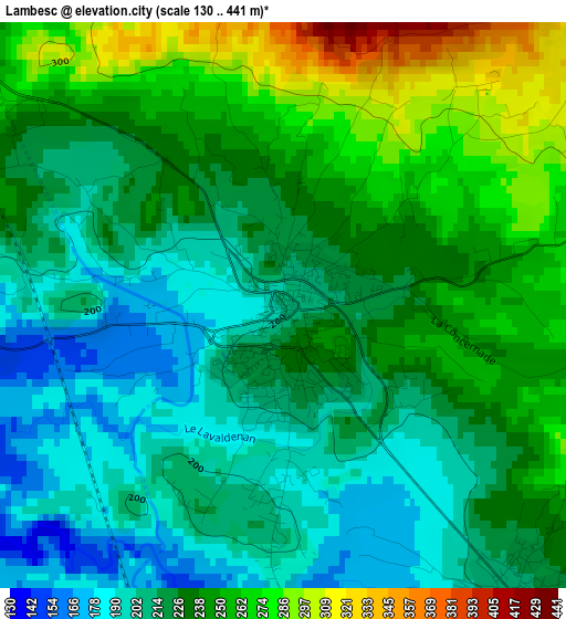
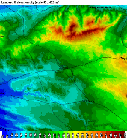
Below is the Elevation map of Lambesc, which displays elevation range with different colors. Scale of the first map is from 130 to 441 m (427 to 1447 ft) with average elevation of 229.3 meters (=752 ft) [note 1]
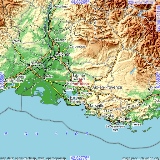
These maps also provides idea of topography and contour of this city, they are displayed at different zoom levels. More info about maps, scale and edge coordinates you can find below images.
| \ | Map #1 | Map #2 | Topo.Map |
| Scale [m] | 130..441 m | 83..482 m | × |
| Scale [ft] | 427..1447 ft | 272..1581 ft | × |
| Average | 229.3 m = 752 ft | 228.4 m = 749 ft | × |
| Width | 7.07 km = 4.4 mi | 14.14 km = 8.8 mi | 226.3 km = 140.6 mi |
| Height | 7.07 km = 4.4 mi | 14.14 km = 8.8 mi | 226.3 km = 140.6 mi |
| ↑Max Latitude | 43.685607° | 43.717377° | 44.66265° |
| Latitude at center | 43.65382° | 43.65382° | 43.65382° |
| ↓Min Latitude | 43.622016° | 43.590195° | 42.62775° |
| ← Min Longitude | 5.218165° | 5.174219° | 3.85586° |
| Longitude center | 5.26211° | 5.26211° | 5.26211° |
| →Max Longitude | 5.306055° | 5.350001° | 6.66836° |
Nearby cities:
Cities around Lambesc sort by population:
• Pélissanne elevation 85 m
9.2 km,  255°
255°
• Éguilles 271 m
12.1 km,  141°
141°
• La Roque-d’Anthéron 168 m
7.8 km,  29°
29°
• Mallemort 132 m
10.9 km,  322°
322°
• Saint-Cannat 220 m
4.6 km, 141°
• Rognes 316 m
6.9 km,  80°
80°
• Lauris 190 m
11.2 km,  21°
21°
• Coudoux 106 m
10.7 km,  185°
185°
• Charleval 151 m
7.3 km,  349°
349°
• Alleins 163 m
9.8 km,  304°
304°
• Mérindol 161 m
12.2 km,  337°
337°
• Vernègues 302 m
8.1 km, 295°
Multilingual:
 En español:
Lambesc elevación 211 m.
 En France:
Lambesc élévation 211 m.


Sources and notes:
- [note 1] Map square and city borders are not equal. Map elevation data is calculated only from area inside that square.
- [src 1] Elevation data from geonames database provided with same terms of usage.
- [src 2] The elevation map of Lambesc is generated using elevation data from NASA's 3 arcsec (90m) resolution SRTM data.
- [src 3] Base (background) map © OpenStreetMap contributors tiles are generated by Geofabrik and OpenTopoMap.
Copyright & License:
This Lambesc Elevation Map is licensed under CC BY-SA. You may reuse any part from this page, if you give a proper credit by linking to this URL:
 More info on terms of use page.