Lannemezan elevation
Lannemezan (Occitanie, Département des Hautes-Pyrénées), France elevation is 594 meters and Lannemezan elevation in feet is 1949 ft above sea level [src 1]. Lannemezan is a populated place (feature code) with elevation that is 420 meters (1378 ft) bigger than average city elevation in France.
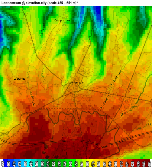
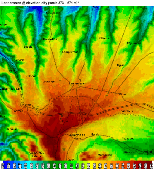
Below is the Elevation map of Lannemezan, which displays elevation range with different colors. Scale of the first map is from 455 to 651 m (1493 to 2136 ft) with average elevation of 583.8 meters (=1915 ft) [note 1]
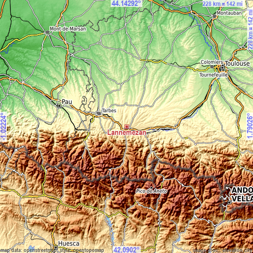
These maps also provides idea of topography and contour of this city, they are displayed at different zoom levels. More info about maps, scale and edge coordinates you can find below images.
| \ | Map #1 | Map #2 | Topo.Map |
| Scale [m] | 455..651 m | 373..671 m | × |
| Scale [ft] | 1493..2136 ft | 1224..2201 ft | × |
| Average | 583.8 m = 1915 ft | 546.3 m = 1792 ft | × |
| Width | 7.13 km = 4.4 mi | 14.27 km = 8.9 mi | 228.2 km = 141.8 mi |
| Height | 7.13 km = 4.4 mi | 14.27 km = 8.9 mi | 228.2 km = 141.8 mi |
| ↑Max Latitude | 43.157236° | 43.189284° | 44.14292° |
| Latitude at center | 43.12517° | 43.12517° | 43.12517° |
| ↓Min Latitude | 43.093088° | 43.060988° | 42.0902° |
| ← Min Longitude | 0.340065° | 0.296119° | -1.02224° |
| Longitude center | 0.38401° | 0.38401° | 0.38401° |
| →Max Longitude | 0.427955° | 0.471901° | 1.79026° |
Nearby cities:
Cities around Lannemezan sort by population:
• Bagnères-de-Bigorre elevation 560 m
20.2 km,  250°
250°
• Barbazan-Debat 358 m
22.8 km,  290°
290°
• Montréjeau 470 m
15.3 km,  106°
106°
• Gourdan-Polignan 430 m
16.6 km, 111°
• Campan 662 m
20.7 km,  233°
233°
• Villeneuve-de-Rivière 465 m
22.7 km,  89°
89°
• Tournay 269 m
13.1 km,  300°
300°
• La Barthe-de-Neste 580 m
4.9 km,  179°
179°
• Gerde 584 m
19.2 km, 246°
• Capvern 612 m
6 km, 246°
• Pouzac 507 m
20.7 km,  257°
257°
• Trie-sur-Baïse 251 m
23.2 km,  356°
356°
Multilingual:
 En español:
Lannemezan elevación 594 m.
 En France:
Lannemezan élévation 594 m.
 Auf Deutsch:
Lannemezan höhe über dem Meeresspiegel ist 594 m.

Sources and notes:
- [note 1] Map square and city borders are not equal. Map elevation data is calculated only from area inside that square.
- [src 1] Elevation data from geonames database provided with same terms of usage.
- [src 2] The elevation map of Lannemezan is generated using elevation data from NASA's 3 arcsec (90m) resolution SRTM data.
- [src 3] Base (background) map © OpenStreetMap contributors tiles are generated by Geofabrik and OpenTopoMap.
Copyright & License:
This Lannemezan Elevation Map is licensed under CC BY-SA. You may reuse any part from this page, if you give a proper credit by linking to this URL:
 More info on terms of use page.