La Salvetat-Peyralès elevation
La Salvetat-Peyralès (Occitanie, Département de l'Aveyron), France elevation is 531 meters and La Salvetat-Peyralès elevation in feet is 1742 ft above sea level [src 1]. La Salvetat-Peyralès is a populated place (feature code) with elevation that is 357 meters (1171 ft) bigger than average city elevation in France.
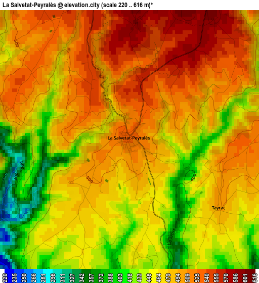
Below is the Elevation map of La Salvetat-Peyralès, which displays elevation range with different colors. Scale of the first map is from 220 to 616 m (722 to 2021 ft) with average elevation of 480.2 meters (=1575 ft) [note 1]
These maps also provides idea of topography and contour of this city, they are displayed at different zoom levels. More info about maps, scale and edge coordinates you can find below images.
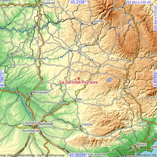
| \ | Map #1 | Topo.Map |
| Scale [m] | 220..616 m | × |
| Scale [ft] | 722..2021 ft | × |
| Average | 480.2 m = 1575 ft | × |
| Width | 7 km = 4.3 mi | 224.1 km = 139.2 mi |
| Height | 7 km = 4.3 mi | 224.1 km = 139.2 mi |
| ↑Max Latitude | 44.250886° | 45.2186° |
| Latitude at center | 44.2194° | 44.2194° |
| ↓Min Latitude | 44.187897° | 43.20295° |
| ← Min Longitude | 2.159025° | 0.79672° |
| Longitude center | 2.20297° | 2.20297° |
| →Max Longitude | 2.246915° | 3.60922° |
Nearby cities:
Cities around La Salvetat-Peyralès sort by population:
• Villefranche-de-Rouergue elevation 269 m
19.8 km,  318°
318°
• Carmaux 245 m
19.1 km,  190°
190°
• Blaye-les-Mines 342 m
21.7 km,  195°
195°
• Baraqueville 793 m
19.3 km,  70°
70°
• Saint-Benoît-de-Carmaux 286 m
19.7 km, 197°
• Naucelle 500 m
11.4 km,  101°
101°
• Rieupeyroux 711 m
10.2 km,  15°
15°
• Rignac 501 m
22.1 km, 18°
• Monestiés 253 m
18.9 km,  205°
205°
• La Fouillade 418 m
13.1 km,  275°
275°
• Mirandol-Bourgnounac 403 m
9 km, 197°
• Colombiès 697 m
17.5 km,  37°
37°
Multilingual:
 En español:
La Salvetat-Peyralès elevación 531 m.
 En France:
La Salvetat-Peyralès élévation 531 m.
 Auf Deutsch:
La Salvetat-Peyralès höhe über dem Meeresspiegel ist 531 m.
 На русском:
La Salvetat-Peyralès высота над уровнем моря 531 м
Sources and notes:
- [note 1] Map square and city borders are not equal. Map elevation data is calculated only from area inside that square.
- [src 1] Elevation data from geonames database provided with same terms of usage.
- [src 2] The elevation map of La Salvetat-Peyralès is generated using elevation data from NASA's 3 arcsec (90m) resolution SRTM data.
- [src 3] Base (background) map © OpenStreetMap contributors tiles are generated by Geofabrik and OpenTopoMap.
Copyright & License:
This La Salvetat-Peyralès Elevation Map is licensed under CC BY-SA. You may reuse any part from this page, if you give a proper credit by linking to this URL:
 More info on terms of use page.