Le Lude elevation
Le Lude (Pays de la Loire, Sarthe), France elevation is 51 meters and Le Lude elevation in feet is 167 ft above sea level [src 1]. Le Lude is a populated place (feature code) with elevation that is 123 meters (404 ft) smaller than average city elevation in France.
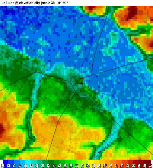
Below is the Elevation map of Le Lude, which displays elevation range with different colors. Scale of the first map is from 30 to 91 m (98 to 299 ft) with average elevation of 49.9 meters (=164 ft) [note 1]
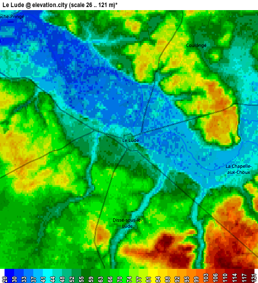
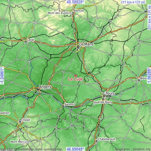
These maps also provides idea of topography and contour of this city, they are displayed at different zoom levels. More info about maps, scale and edge coordinates you can find below images.
| \ | Map #1 | Map #2 | Topo.Map |
| Scale [m] | 30..91 m | 26..121 m | × |
| Scale [ft] | 98..299 ft | 85..397 ft | × |
| Average | 49.9 m = 164 ft | 61.3 m = 201 ft | × |
| Width | 6.58 km = 4.1 mi | 13.17 km = 8.2 mi | 210.7 km = 130.9 mi |
| Height | 6.58 km = 4.1 mi | 13.17 km = 8.2 mi | 210.7 km = 130.9 mi |
| ↑Max Latitude | 47.676078° | 47.705659° | 48.58529° |
| Latitude at center | 47.64648° | 47.64648° | 47.64648° |
| ↓Min Latitude | 47.616866° | 47.587234° | 46.69049° |
| ← Min Longitude | 0.112695° | 0.068749° | -1.24961° |
| Longitude center | 0.15664° | 0.15664° | 0.15664° |
| →Max Longitude | 0.200585° | 0.244531° | 1.56289° |
Nearby cities:
Cities around Le Lude sort by population:
• La Flèche elevation 33 m
18.3 km,  288°
288°
• Mayet 81 m
15.4 km,  35°
35°
• Aubigné-Racan 59 m
9.7 km,  59°
59°
• Noyant 84 m
15.4 km,  190°
190°
• Vaas 47 m
12.2 km,  78°
78°
• Château-la-Vallière 97 m
16.8 km,  131°
131°
• Luché-Pringé 43 m
8.8 km,  316°
316°
• Mansigné 61 m
11.5 km,  351°
351°
• Pontvallain 55 m
12 km,  12°
12°
• Clermont-Créans 40 m
15.1 km,  301°
301°
• Luceau 84 m
19.4 km,  68°
68°
• Requeil 78 m
15.3 km,  1°
1°
Multilingual:
 En español:
Le Lude elevación 51 m.
 En France:
Le Lude élévation 51 m.


Sources and notes:
- [note 1] Map square and city borders are not equal. Map elevation data is calculated only from area inside that square.
- [src 1] Elevation data from geonames database provided with same terms of usage.
- [src 2] The elevation map of Le Lude is generated using elevation data from NASA's 3 arcsec (90m) resolution SRTM data.
- [src 3] Base (background) map © OpenStreetMap contributors tiles are generated by Geofabrik and OpenTopoMap.
Copyright & License:
This Le Lude Elevation Map is licensed under CC BY-SA. You may reuse any part from this page, if you give a proper credit by linking to this URL:
 More info on terms of use page.