Le Mayet-de-Montagne elevation
Le Mayet-de-Montagne (Auvergne-Rhône-Alpes, Département de l'Allier), France elevation is 540 meters and Le Mayet-de-Montagne elevation in feet is 1772 ft above sea level [src 1]. Le Mayet-de-Montagne is a populated place (feature code) with elevation that is 366 meters (1201 ft) bigger than average city elevation in France.
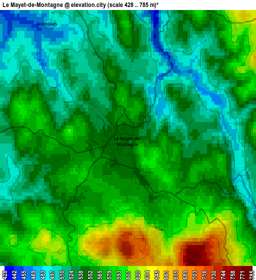
Below is the Elevation map of Le Mayet-de-Montagne, which displays elevation range with different colors. Scale of the first map is from 428 to 785 m (1404 to 2575 ft) with average elevation of 552.9 meters (=1814 ft) [note 1]
These maps also provides idea of topography and contour of this city, they are displayed at different zoom levels. More info about maps, scale and edge coordinates you can find below images.
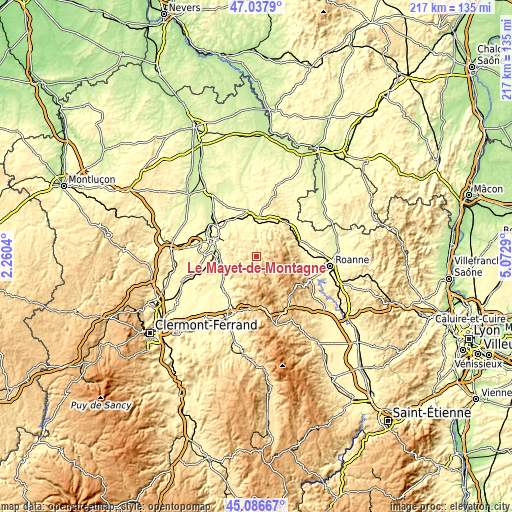
| \ | Map #1 | Topo.Map |
| Scale [m] | 428..785 m | × |
| Scale [ft] | 1404..2575 ft | × |
| Average | 552.9 m = 1814 ft | × |
| Width | 6.78 km = 4.2 mi | 217 km = 134.8 mi |
| Height | 6.78 km = 4.2 mi | 216.9 km = 134.8 mi |
| ↑Max Latitude | 46.101389° | 47.0379° |
| Latitude at center | 46.07091° | 46.07091° |
| ↓Min Latitude | 46.040414° | 45.08667° |
| ← Min Longitude | 3.622705° | 2.2604° |
| Longitude center | 3.66665° | 3.66665° |
| →Max Longitude | 3.710595° | 5.0729° |
Nearby cities:
Cities around Le Mayet-de-Montagne sort by population:
• Vichy elevation 274 m
19.6 km,  288°
288°
• Cusset 282 m
17.7 km, 293°
• Lapalisse 280 m
19.9 km,  353°
353°
• Creuzier-le-Vieux 339 m
20.7 km,  299°
299°
• Saint-Yorre 288 m
15.6 km,  267°
267°
• Renaison 370 m
20 km,  96°
96°
• Puy-Guillaume 282 m
19.3 km,  230°
230°
• Abrest 324 m
17.4 km,  280°
280°
• Ambierle 370 m
17.9 km,  77°
77°
• Paslières 388 m
20.5 km,  219°
219°
• La Pacaudière 335 m
19.3 km,  51°
51°
• Hauterive 259 m
17.1 km, 276°
Multilingual:
 En español:
Le Mayet-de-Montagne elevación 540 m.
 En France:
Le Mayet-de-Montagne élévation 540 m.
 Auf Deutsch:
Le Mayet-de-Montagne höhe über dem Meeresspiegel ist 540 m.
 На русском:
Ле-Майе-де-Монтань высота над уровнем моря 540 м
Sources and notes:
- [note 1] Map square and city borders are not equal. Map elevation data is calculated only from area inside that square.
- [src 1] Elevation data from geonames database provided with same terms of usage.
- [src 2] The elevation map of Le Mayet-de-Montagne is generated using elevation data from NASA's 3 arcsec (90m) resolution SRTM data.
- [src 3] Base (background) map © OpenStreetMap contributors tiles are generated by Geofabrik and OpenTopoMap.
Copyright & License:
This Le Mayet-de-Montagne Elevation Map is licensed under CC BY-SA. You may reuse any part from this page, if you give a proper credit by linking to this URL:
 More info on terms of use page.