Le Péage-de-Roussillon elevation
Le Péage-de-Roussillon (Auvergne-Rhône-Alpes, Département de l'Isère), France elevation is 170 meters and Le Péage-de-Roussillon elevation in feet is 558 ft above sea level [src 1]. Le Péage-de-Roussillon is a populated place (feature code) with elevation that is 4 meters (13 ft) smaller than average city elevation in France.
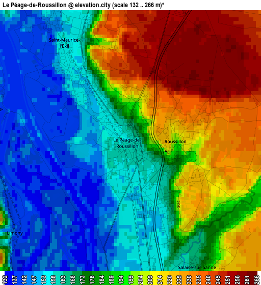
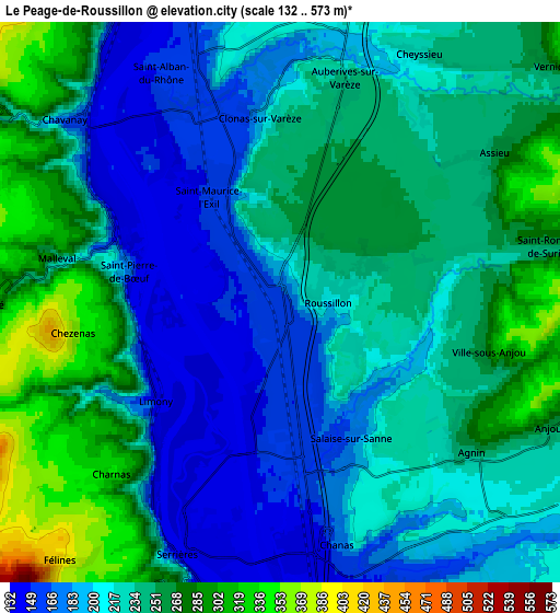
Below is the Elevation map of Le Péage-de-Roussillon, which displays elevation range with different colors. Scale of the first map is from 132 to 266 m (433 to 873 ft) with average elevation of 185.5 meters (=609 ft) [note 1]
These maps also provides idea of topography and contour of this city, they are displayed at different zoom levels. More info about maps, scale and edge coordinates you can find below images.
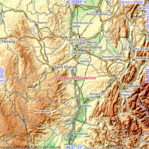
| \ | Map #1 | Map #2 | Topo.Map |
| Scale [m] | 132..266 m | 132..573 m | × |
| Scale [ft] | 433..873 ft | 433..1880 ft | × |
| Average | 185.5 m = 609 ft | 227.8 m = 747 ft | × |
| Width | 6.86 km = 4.3 mi | 13.73 km = 8.5 mi | 219.7 km = 136.5 mi |
| Height | 6.86 km = 4.3 mi | 13.73 km = 8.5 mi | 219.7 km = 136.5 mi |
| ↑Max Latitude | 45.404662° | 45.435508° | 46.35303° |
| Latitude at center | 45.3738° | 45.3738° | 45.3738° |
| ↓Min Latitude | 45.342921° | 45.312025° | 44.37731° |
| ← Min Longitude | 4.753325° | 4.709379° | 3.39102° |
| Longitude center | 4.79727° | 4.79727° | 4.79727° |
| →Max Longitude | 4.841215° | 4.885161° | 6.20352° |
Nearby cities:
Cities around Le Péage-de-Roussillon sort by population:
• Roussillon elevation 219 m
1.4 km,  89°
89°
• Salaise-sur-Sanne 187 m
2.7 km,  157°
157°
• Saint-Clair-du-Rhône 249 m
7.8 km,  344°
344°
• Chavanay 147 m
7.3 km,  310°
310°
• Chanas 181 m
6.3 km, 164°
• Sablons 136 m
6.1 km,  196°
196°
• Auberives-sur-Varèze 239 m
5.5 km,  18°
18°
• Clonas-sur-Varèze 189 m
4.5 km,  353°
353°
• Saint-Pierre-de-Bœuf 222 m
3.8 km,  257°
257°
• Serrières 142 m
6.8 km, 203°
• Félines 370 m
8.3 km,  220°
220°
• Ville-sous-Anjou 238 m
4.2 km, 91°
Multilingual:
 En español:
Le Péage-de-Roussillon elevación 170 m.
 En France:
Le Péage-de-Roussillon élévation 170 m.
 Auf Deutsch:
Le Péage-de-Roussillon höhe über dem Meeresspiegel ist 170 m.
 На русском:
Le Péage-de-Roussillon высота над уровнем моря 170 м
Sources and notes:
- [note 1] Map square and city borders are not equal. Map elevation data is calculated only from area inside that square.
- [src 1] Elevation data from geonames database provided with same terms of usage.
- [src 2] The elevation map of Le Péage-de-Roussillon is generated using elevation data from NASA's 3 arcsec (90m) resolution SRTM data.
- [src 3] Base (background) map © OpenStreetMap contributors tiles are generated by Geofabrik and OpenTopoMap.
Copyright & License:
This Le Péage-de-Roussillon Elevation Map is licensed under CC BY-SA. You may reuse any part from this page, if you give a proper credit by linking to this URL:
 More info on terms of use page.